Your Donations Count Donate Graphicat the Westside Observer!

Cop27_Egypt
.Photo courtesy of Nature Conservancy

Heeding the Clarion Call for Climate Reparations

United Nations’ COP27 / Healing Starts at Hunters Point

Dr. Ahimsa Sumchai
Dr. Ahimsa Sumchai

•••••••••• November 22, 2022 ••••••••••

The air we breathe, the food we eat, the water we drink, indeed our health, wellbeing and survival all depend on a clean, healthy and sustainable environment."
ASG Brands Kehris, United Nations Office of the High Commissioner for Human Rights

On October 8, 2021 the global environmental health and justice movement soared to new heights when the United Nations Human Rights Council adopted an historic resolution recognizing a clean, healthy and sustainable environment as a human right.

The hard-fought adoption of UN Resolution 48-13 followed a momentous year for environmental justice when President Joe Biden issued an Executive Order Protecting Public Health and the Environment and Restoring Science to Tackle the Climate Crisis, on January 20, 2021.

"This form of environmental racism poses serious and disproportionate threats to the enjoyment of several human rights of its largely African American residents, including the right to equality and non-discrimination, the right to life, the right to health, the right to an adequate standard of living and cultural rights."

Demonstrators
The moment we are in - the moment we must seize! Over 150 nations protect the fundamental right to a healthy environment through constitutional laws, judicial rulings and ratification of international treaties. Photo courtesy New York Times

Earlier that year, on March 2, 2021, the UN Human Rights Council issued a condemnation of "environmental racism" in response to a government decision to site a highly polluting industry in a predominantly Black corridor along the Mississippi River, lined with over a hundred refineries and petrochemical plants. EPA data documented the nation's highest cancer risks from air pollution in Louisiana's "Cancer Alley."

Law Professor Maxine Burkett coined the term climate reparations as "the understanding of climate change as a monumental injustice that needs to be addressed through law and policy." In examining the past, present, and future of climate reparations, the recalculation of global debt must account for all that was stolen through slavery and colonialism and lives lost and shortened by environmental injustice.

The latest UN climate report highlights how communities that contribute the least to climate change suffer the most. [Climate Change 2022: Impacts, Adaptation and Vulnerabilities.]

protester
A protester holds a Climate Reparations Now placard during a November 2021 London demonstration. Image courtesy ZUMA Press Wire & Opendemocracy.net

Scientists on the UN Intergovernmental Panel on Climate Change argue 3.5 billion people - roughly 45% of the world's population - live in regions of high vulnerability to climate change…the vast majority live in areas with the world's lowest carbon emissions!

Climate reparations dominated Egypt's UN Climate Change Summit this month as negotiations centered on loss and damages. Developing nations and overburdened communities demand help cutting emissions, adapting to climate change…and compensation for damages! Three key demands made by the Global South agreed to by President Joe Biden and the European Union are:

1. Increase in Climate Finance Grants
2. Increase in Funding for Climate Adaptation
3. Compensation for Loss and Damages Suffered by Frontline Communities

Shipyard Aerial
Bayview Hunters Point (BVHP) is a historically African American community located in heavily industrialized southeast San Francisco on a promontory extending into San Francisco Bay. The region's rich legacy of racial, ethnic and cultural diversity originated 10,000 years ago when the "First People" cultivated its tidal wetlands - the Ramaytush Ohlone.

Spanish missionaries colonized the promontory in the 1770's and by 1850 a "gold rush" of diversification drove Chinese shrimp merchants, Italian cattle ranchers and wealthy real estate moguls into southeast San Francisco. By 1869, "The Worlds Greatest Shipping Yard" had been established by the Hunter Brothers - who lived in a mansion on Oakdale Avenue in modern-day Hunters Point.

"Speak softly but carry a big stick!"

Atlantic Fleet
US President Theodore Roosevelt’s Atlantic Fleet enters San Francisco Bay on May 6, 1908. Photo: John Rothschild

President Theodore Roosevelt's use of this African proverb as a motto is exemplified by the San Francisco Bay arrival of the "Great White Fleet" on May 6, 1908, en route to "The World's Greatest Shipping Yard" at the Hunters Point Drydocks. Following maintenance and refueling, on July 7, 1908, the armada of 16 gold-gilded battleships departed Hunters Point on a Tour de Force around the world.

Caution - Radioactive

US entry into World War II in 1941 marked the Atomic Age - an era of widespread chemical and radiation contamination of the Hunters Point Naval Shipyard (HPNS) and adjoining neighborhoods. The great migration of African Americans - included my grandparents - who journeyed from Texas and Louisiana to work in the post-World War II HPNS.

Father and grandfather
Circa 1963 - My grandfather George Carter (L) and my father George Porter (R) - ILWU longshoremen. Carter migrated from Texas to work at HPNS and returned years later to purchase land.

The shipyard's closure in 1974 prompted a severe economic downturn. Segregation landlocked African Americans into San Francisco's southeast corner in populations as high as 60% via housing discrimination, blight and racially restrictive covenants, compounded by redevelopment, displacement and job loss as markets shifted from skilled labor to the service sector.

The role of redevelopment in the displacement of the African American population has been likened to ethnic cleansing. Redevelopment projects in BVHP became a neighborhood focus in the 1990s and continue to play a divisive and hotly contested role in community and government relations. The 2010 Shipyard/Candlestick Redevelopment plan incorporates 1300 acres of existing residential, commercial and industrial lands.

Modern-day BVHP has been radically transformed by gentrification. "Negro removal" was wildly successful. According to the 2010 census, African Americans comprised 21.5% of the population in the 8.6-mile region designated San Francisco County South Central Bayview Hunters Point.

Census data in 2020 document the African American population has dwindled to 11% to match the white population. Asians and Pacific Islanders now comprise 48% of the population, while Hispanics constitute 27%.

...
Yosemite Slough — a muddy channel of water that carries sediment from the shipyards contaminated Parcel E-2 shoreline west towards 3rd street.

The geophysically connected Federal Superfund sites include the Hunters Point Naval Shipyard, the Parcel E-2 Industrial Landfill and Yosemite Slough. A State Superfund site is located on Thomas Street, six blocks west of the base.

The October 24, 1988, Defense Authorization Base Realignment & Closure Act - Public Law 100-526 is the congressionally authorized process used by the DoD to coordinate the transfer of military installations into civilian reuse.

In 1989 EPA designated HP Naval Shipyard a federal Superfund site, assigning it a Hazard Ranking Score of 80 and placing it atop the National Priorities List of the nation's most contaminated properties.

Landfill Panhandle
Current conditions at Parcel E-2. Looking south from adjacent hillside

The Naval Radiological Defense Laboratories operated as a campus on the shipyard's southern shoreline from 1946 to 1969. In 1955, while residents lived in private homes, public housing and mansions within feet of the western fence line bordering the naval base, the Navy began dumping radioactive waste into a 46-acre unlined industrial landfill.

The landfill area outlined in red incorporates the entire Parcel E-2 shoreline. At its western border is a broken, unfortified chain metal fence located within fifty feet of homes, playgrounds, churches and community centers.

Report Cover
San Francisco Civil Grand Jury 2021-2022

The Parcel E-2 landfill is the subject of an investigation by the San Francisco Superior Court Civil Grand Jury released on June 1, 2022. The report reinforces the findings of the San Francisco Climate and Health Profile that ranks neighborhoods on a scale of one through five on resiliency to climate change. BVHP ranked number one for risk of floods, landslides and heat vulnerability. Twenty-seven percent of the region is at risk for environmental contamination. The EPA Hunters Point Naval Shipyard/Superfund Site cumulus lists 25 pages of chemicals and radionuclides of concern.

Many of these chemicals are detected by the Hunters Point Community Biomonitoring Program in urinary screenings conducted on residents and workers within the one-mile perimeter of the naval base. The findings of the Civil Grand Jury validate the chemical and cancer clusters geospatially mapped by HP Biomonitoring.

...
Revere Avenue/Fitch Street intersection at the western fence line of the radiation-contaminated Parcel E-2 landfill and shoreline located half a mile east from the major neighborhood transit corridor at Third Street and Revere.

SLOW VIOLENCE AT THE HUNTERS POINT NAVAL SHIPYARD

"Military bases are extremely polluted, often contaminated with industrial wastes, along with various chemical, biological and nuclear weapons of war. Today many former bases are converted to civilian use, a process requiring extensive remediation. The reuse of military bases involves extracting toxic sediments as well as the sedimented histories of war and military violence. Slow violence emphasizes the dispersed and slow-moving forms of environmental disaster and toxic suffering, expanding the spatiality's and temporalities by which we might understand environmental injustice."

Lindsey Dillon, PhD - War's Remains: Slow Violence and the Urbanization of Military Bases in California

The Hunters Point Community Biomonitoring Program (HP Biomonitoring) was launched in January 2019 to offer low-cost, accurate urinary toxicology and nutrient screenings to residents and workers within the one-mile perimeter of the Hunters Point Naval Shipyard.

In four years of operation, HP Biomonitoring has advanced environmental public health, amassed media acclaim and prestigious awards for pioneering achievements in cross-referencing and geospatial mappings of data derived from urinary screenings conducted at the point of exposure with detailed environmental health evaluations and historical data derived from Superfund site characterizations.

These findings are further amplified using environmental geographic information, mapping and tracking tools including the EPA EJScreen, CalEnviroScreen 4.0, BAAQMD Interactive Mapping and Pollution Complaints, SaTscan cluster mapping tool and the Bayview Hunters Point IVAN (Identifying Violations Affecting Neighborhoods www.bvhp-ivan.org).

IVAN operates as a community-based environmental reporting and enforcement tool designed to connect residents with government agencies and environmental regulators responsible for addressing and resolving serious and chronic environmental offenses. IVAN is operated by Greenaction for Health & Environmental Justice. Complaints are reviewed at a monthly EJ Task Force. IVAN posts real-time data from eight stationary air monitors installed in BVHP and issues air quality alerts from the Marie Harrison Bayview Air Monitoring Network.

EJ Screen
The EPA EJScreen environmental mapping tool documents the heavily industrialized 94124 zip code to be in the 95th to 100th percentile for environmental health indicators, including PM 2.5, diesel particulates, NATA Air Toxics Cancer Risk, coronary heart disease, asthma and low life expectancy.

The growing impact of community exposures to landfills, toxic dumps, industrial waste sites, polluting industries and military installations drives the environmental public health initiative to institute toxic registries capable of enrolling vulnerable populations faced with life-threatening exposures to toxicants with generational impacts on health, safety and life expectancy.

Toxic tort settlements established registries offering a spectrum of medical, legal, occupational and social services delivered by a medically supervised institute that monitors programs and outcomes for generations. Toxic registries operate in Flint, Michigan, Camp Lejeune and for thousands of first responders exposed to toxic dust and debris enrolled by the World Trade Center Health Program. The VA Environmental and Burn Pit Registries are the nation's largest. Atomic bomb survivor registries in Japan offer valuable insight into the care of the world's largest radiation-exposed populations.

The community-led initiative to establish the Flint Lead Exposure Registry was adopted by the Centers for Disease Control after a Flint resident, appointed to the Flint Water Taskforce, proposed a toxic registry in 2016. The Congressional Water Infrastructure Improvements Act funded a four-year grant to the CDC to create the Flint Lead Exposure Registry.

In 2017, the Michigan Department of Health and Human Services funded the Michigan State University Public Health Initiative to develop a toxic registry. In partnership with the Greater Flint Health Coalition and the City of Flint, Michigan State University received the Flint Registry grant for 2017-2021.

The Hunters Point Biomonitoring Foundation's mission is to establish the Hunters Point Community Toxic Registry. The most valuable deliverable of HP Biomonitoring's pioneering work is creating a successful model of community exposure research that is transferrable and directly applicable to environmental justice-impacted communities across the nation.

Simple criteria for enrollment in a toxic registry are risk and proof of exposure to an environmental release…either acute or chronic. The findings of the Hunters Point Community Biomonitoring Program show the intensity and severity of exposure. Findings are factored by the duration of exposure, proximity to the source and age, but chemicals of concern are predictably detected in residents and workers within the half-mile perimeter of the Hunters Point Naval Shipyard.

The Hunters Point Community Toxic Registry enshrines the highest mission, cumulative skills, knowledge and abilities of partners. It is dedicated to establishing cause-and-effect relationships between environmental exposures and expressions of disease and delivery of state-of-the-art interventions, medicolegal referrals and advocacy to heal a wounded community.

Cancer Necklace in San Francisco

Ahimsa Porter Sumchai MD - Former Attending Physician, Palo Alto Veterans Administration Persian Gulf, Agent Orange, Ionizing Radiation Registry - 1997

November 22, 2022

PGE Power Plant
The PG &E power plant at Hunters Point was an oil-fired facility that dumped pollutants into the atmosphere and its effects continue today.PG&E circa 1997 photo: Chris Carlsson_

Overreach at the Supreme Court

West Virginia v. Environmental Protecction Agency

Dr. Ahimsa Sumchai
Dr. Ahimsa Sumchai

•••••••••• July 19, 2022 ••••••••••

"At this moment, when the impacts of the climate crisis are becoming ever more disruptive, costing billions of dollars every year from floods, wildfires, droughts and sea level rise, and jeopardizing the safety of millions of Americans, the court's ruling is disheartening." Michael Regan — EPA Administrator

O On Thursday, June 30, 2022, the Supreme Court of the United States issued a devastating decision in West Virginia et al. v Environmental Protection Agency et al. Excerpts from the syllabus of the decision read:

"In 2015, the Environmental Protection Agency (EPA) promulgated the Clean Power Plan rule, which addressed carbon dioxide emissions from coal and natural gas-fired power plants. For authority, the Agency cited Section 111 of the Clean Air Act…known as the New Source Performance Standards program, also authorizes regulation of certain pollutants from existing sources. Under that provision, although the States set the actual enforceable rules governing existing sources, EPA determines the emissions limit with which they will have to comply." The Agency derives that limit by determining the best system of emission reduction…BSER. In the Clean Power Plan, EPA determined that the BSER for existing coal and natural gas plants included three types of measures, which the Agency calls "building blocks". The first building block was "heat rate improvements" at coal- fired plants — practices such plants could undertake to burn coal more cleanly. This Court stayed the Clean Power Plan in 2016, preventing the rule from taking effect." [Supreme Court of the United States October Term 2021]

quote marks

Biden called the Supreme Court decision a "devastating decision" that "risks damaging our nation's ability to keep our air clean and combat climate change.”

Chief Justice Roberts delivered the opinion of the court in the 89-page decision. In excerpt it reads:

"The Clean Air Act authorizes the Environmental Protection Agency to regulate power plants by setting a "standard of performance" for the emission of certain pollutants into the air. Since passage of the Act 50 years ago, EPA has exercised this authority by setting performance standards based on measures that would reduce pollution by causing plants to operate more cleanly. In 2015, however, EPA issued a new rule concluding that the "best system of emission reduction" for existing coal-fired power plants included a requirement that such facilities reduce their own production of electricity or subsidize increased generation by natural gas, wind or solar sources. The question before us is whether this broader conception of EPA's authority is within the power granted to it by the Clean Air Act."

In a 6–3 opinion divided along political and ideological lines, the nations high court ruled to limit the EPA's ability to strictly regulate emissions from power plants. The ruling addresses EPA's authority granted by former President Obama's Clean Power Plan, to enforce mandates for power plant emissions. The plan was never implemented — held back by legal challenges.

The Supreme Court decision specifically addresses capping carbon dioxide emissions and opines "it is not plausible that Congress gave EPA authority to adopt on its own such a regulatory scheme" and that "a decision of such magnitude and consequence resides with Congress".

The court opinion signals a devastating setback in the fight against climate change and air pollution disproportionately impacting heavily industrialized shoreline communities of color from Cancer Alley, Louisiana to San Francisco's Bayview Hunters Point. Greenhouse gases like carbon dioxide, trap heat in the atmosphere and increase global temperatures.

...

President Biden issued a Presidential Action on January 20, 2021 in an Executive Order on Protecting Public Health and the Environment and Restoring Science to Tackle the Climate Crisis. Biden called the Supreme Court decision a "devastating decision" that "risks damaging our nation's ability to keep our air clean and combat climate change."

Biomonitoring detects pollution in people. The Hunters Point Biomonitoring Program launched in January of 2019 offers residents and workers living within the one-mile buffer zone of a system of three federal Superfund sites access to low-cost, reliable urinary toxic exposure screenings capable of detecting up to 35 toxicants — including radioactive and carcinogenic heavy metals commonly detected in fugitive dust emissions and toxic air contaminants.

The people of Bayview Hunters Point courageously fought to close and demolish the PG&E Power Plant. Forming a powerful coalition that surged over decades led by Marie Harrison and the Hunters View Mothers' Committee, it included medical researchers, environmental activists, clergy, elected officials, a brigade of environmental law attorneys and government regulators.

Power Plant Pollutants Map
The EPA EJScreen identifies Hunters Point as being in the 95th to 100th percentile for particulate 2.5, diesel particulates and Air Toxics Cancer Risk

Residents sounded the alarm that power plant emissions formed black soot on windows and doorways in their homes and triggered asthma attacks, headaches and nosebleeds in their children. Greenaction and the Hunters View Mothers Committee led the successful fight that ultimately closed the PG&E Hunters Point power plant in 2006.

Waste from power plant
PG∓E Hunters Point Power Plant 2007 prior to its deconstruction Photo Chris Carlsson

"She kept watching the smoke pouring out of that chimney and heading right at them." Mary Ratcliff — Editor SF Bayview Newspaper

Marie Harrison
Marie Harrison — Hunters View resident and "Mother of the Environmental Justice Movement in Bayview Hunters Point." She died following a cardiopulmonary arrest due to pulmonary fibrosis in 2019. Harrison was on the phone with Greenaction Executive Director Bradley Angel discussing strategies to address worsening air pollution in the neighborhood where she once lived the morning of May 3, 2019 . She went into cardiopulmonary arrest that evening and died on May 5, 2019 .

Two recent studies assessed the outcomes caused by the closure of the PG&E power plant that operated within feet of Hunters View and India Basin residents from 1929 to 2006. A study published in the American Journal of Epidemiology in May found that after eight coal or oil-fired power plants closed between 2001 and 2011 in California that included the Hunters Point PG&E facility, fewer babies were born preterm in the surrounding community. In a study published in Environmental Health, the same researchers found that retiring those eight power plants resulted in an uptick in fertility rates — the number of live births per 1,000 women.

California Oil and Coal-fired plants

Eight California coal and oil-fired power plants closed between 2001 and 2011. UC Berkeley postdoctoral scholar Joan Casey led research that first identified babies born preterm — before 37 weeks of pregnancy — to be at increased risk of cerebral palsy, asthma and death.

"For those living within roughly three miles of the plants, the team concluded that closing the facilities dropped preterm birth rates from seven percent to 5.1 percent, effectively decreasing the number of preemies born by a quarter." Retirements of Coal and Oil Power Plants in California — American Journal of Epidemiology, Casey et al. Volume 187, Issue 8, August 2018

Power Plant Demolished
"A Breath of Fresher Air!" March 2009 — Demolition of the PG&E Power Plant allows a clear view north- photo: Chris Carlsson

According to the Environmental Defense Fund, power plants are one of the single largest contributors to national and global air pollution and climate change and, according to the EPA, account for 24% of greenhouse gas emissions in the U.S. from the burning of fossil fuels. EDF general counsel Vickie Patton called the Supreme Court ruling that sided with coal-mining companies and Republican-led states "judicial overreach."

Air Pollutants

United Nations Resolution

The EPA's authority to involve all stakeholders in developing pollution standards was supported by power companies as well as the American Medical Association and the American Academy of Pediatrics.

The United Nations warned for decades that failing to reduce greenhouse gas emissions would result in extreme, unprecedented adverse impacts around the world, including droughts, wildfires, storm damage and threats to human health, food production, urban infrastructure and the global economy.

The UN concluded its 76th session approving 16 resolutions and two decisions on Protecting Global Climate and expressing profound alarm that greenhouse gas emissions continue to rise globally. In "Protection of global climate for present and future generations of humankind" the General Assembly emphasized mitigation and adaptation to climate change represents an immediate global priority.

Justice Elena Kagan's Dissent

"The stakes here are high. Yet the Court today prevents congressionally authorized agency action to curb power plants carbon dioxide emissions. The Court appoints itself — instead of Congress or the expert agency — the decision maker on climate policy. I cannot think of many things more frightening." [Read the Supreme Court's EPA Decision, Elena Kagan's Dissent]

The Hunters Point Biomonitoring Foundation believes the ultimate power and courage of environmental activism and citizen science will prevail in overturning a decision described in dissenting opinion by Justice Elena Kagan as "frightening."

The Hunters Point Biomonitoring Foundation stands firm in the conviction that the acceptance and application of human biomonitoring (HBM) will advance environmental public health and play a decisive role in governmental policy to calm the rising tide of global sea levels, disperse the dark clouds of toxic airborne emissions and mitigate adverse health effects.

The most overlooked example of the power of human biomonitoring is documented in declining blood lead levels that occurred from 1970 to 1990 following the elimination of lead in gasoline. Lead is a naturally occurring metal used in the production of fuels and paint. In 1971, Congress banned the use of lead-based paint in residential projects and, effective January 1, 1996, leaded gasoline was banned by the Clean Air Act for use in new vehicles as a direct result of human biomonitoring. The United Nations estimates the global phaseout of the toxic fuel saved $2.44 trillion per year due to health improvements and prevented over 1.2 million premature deaths.

...

The Hunters Point Biomonitoring Foundation, Inc stands proud in our belief in the words of MLK… "that unarmed truth and unconditional love will have the final word"!

References:
1. Biomonioring — Lead/US EPA https://www.epa.gov/americaschildrenenvironment/biomonitoring-lead
2. Full Text: Read the Supreme Court's EPA Decision, Elena Kagan's Dissent.https://www.bloomberg.com/news/articles/2022–06–30/full-text-read-the-supreme-court-s-epa-decision-elena-kagan-s-dissent
3. https://www.kqed.org/science/1979614/for-these-black-bayview-hunters-point-residents-reparations-include-safeguarding-against-rising-toxic-contamination
4. https://grist.org/article/san-francisco-residents-were-sure-nearby-industry-was-harming-their-health-they-were-right/
5. Energy & Environment — What can the EPA still do on power plants?https://thehill.com/policy/energy-environment/3544291-what-the-supreme-court-ruled-the-epa-can-and-cant-do/
6. End of Leaded Galosine: World Has Stopped Using Leaded Gasoline. https://www.npr.org/2021/08/30/1031429212/the-world-has-finally-stopped-using-leaded-gasoline-algeria-used-the-last-stockpile
7. Don't Choose Extinction: https://youtube.com/watch?v=VaTgTiUhEJg&feature=share
8. Biomonitoring California Explore Results: https://biomonitoring.ca.gov/results/explore
9. Human Biomonitoring (HBM) and Geospatial Mapping Applied to Determining Imminent and Proximate Threat to Human Safety at a Federal Superfund System:https://ahimsaportersumchaimd.medium.com/human-biomonitoring-hbm-and-geospatial-mapping-applied-to-determining-imminent-and-proximate-de782db93e3d
10. Human Biomonitoring for Environmental Chemicals: https://www.nap.edu/catalog/11700/human-biomonitoring-for-environmental-chemicals
11. Executive Order on Protecting Public Health and the Environment and Restoring Science to Tackle the Climate Crisis/The White House: https://www.whitehouse.gov/briefing-room/presidential-actions/2021/01/20/executive-order-protecting-public-health-and-environment-and-restoring-science-to-tackle-climate-crisis/
12. Human Biomonitoring- State of the Art- PubMed: https://pubmed.ncbi.nlm.nih.gov/17376741

Ahimsa Sumchai Porter, MD, West Portal, Medical Director Golden State MD Health & Wellness is a longtime neighborhood and environmental activist

JULY 2022

LETHAL COMBINATION: Sea Level Rise and Toxic Groundwater

Toxic Clean UP
Toxic Clean-up is far from finished at the SF Navy Shipyard site

Buried: Civil Grand Jury Excoriates Hunters Point Toxic Clean-up

The June 1st Grand Jury's Report asks: Could rising groundwater of climate change pose special health risks in the heavily polluted Shipyard?

Dr. Ahimsa Sumchai
Dr. Ahimsa Sumchai

The City & County of San Francisco Civil Grand Jury (CGJ) is a government oversight panel of volunteers who make findings and recommendations based on its investigations. On June 1, 2022 the CGJ issued a sweeping investigation titled Buried Problems and a Buried Process: The Hunters Point Naval Shipyard in a Time of Climate Change.

hunters Point
Site of the SF Naval Shipyard Photo by Sergio Ruiz - SF Planning.org

“The Civil Grand Jury began this investigation with a question about the potential impact of groundwater rise due to climate change on the future of the Hunters Point Naval Shipyard … In brief, as sea level rises, shallow groundwater near the shore rises with it, and can cause flooding, damage infrastructure, and mobilize any contaminants in the soil. The Jury asked if rising groundwater could pose special risks to health and safety in the low-lying, heavily polluted landscape of the Shipyard.”

Report Cover
San Francisco Civil Grand Jury 2021-2022

The comprehensive report by the “Citizen Scientists” of the Jury is applaudable but constrained by lack of jurisdiction over the Navy, federal and state regulators. The Jury offered few remedies to frontline neighborhoods while recognizing the instrumental role community-based organizations played in formulating the 2021 - 2022 report.

Hunters Point Biomonitoring researchers met with a team of CGJ investigators in 2021 and 2022, contributing original content to the archive of documents referenced in the report, including geospatial mappings of Shipyard chemicals of concern detected in residents and workers clustered along the radiation contaminated shoreline and western fence line of the base.

The Jury found groundwater will rise along with sea level rise (SLR) and interact with hazardous toxins the Navy plans to leave buried in soil and landfills on the Shipyards southern shoreline. The Jury found the “new science” of SLR identifies risks not fully analyzed by the City and not incorporated into shipyard development plans by the Office of Community Investment and Infrastructure, the Navy and government regulators charged with oversight of the troubled mega development project.  

Shoreline Photo
Photo taken on June 5, 2022 at the easily accessible radiation contaminated Parcel E-2 shoreline. Photo: AP Sumchai
quotes

The CGJ report concludes groundwater at the shipyard “may” become contaminated as sea level rises above the chemical laden shoreline. When, in fact, Shipyard groundwater was documented to be contaminated in 1995 on the Parcel touted to be most “clean” and where thousands of homes are being constructed. ”

The Jury acknowledged, in Finding 3, the process governing the Shipyard cleanup is extremely technical and inhibiting to city leaders who have little understanding of the process.

Bay Area Flooding
The Planning Department projects an estimated 66 inches of sea level rise by the end of the centuryGraphic: John Blanchard / SF Chronicle

An analysis of sea level rise at the Hunters Point shoreline, its vulnerability and consequences is included in the 2020 report of the San Francisco Planning Department. It examined neighborhood profiles in Bayview South/Hunters Point and Bayview North/Islais Creek. The Planning Department projects an estimated 66 inches of sea level rise by the end of the century. Currently, an unfortified chain metal fence separates the radiation contaminated Parcel E-2 shoreline, industrial landfill and South Basin shoreline from an estimated 35,000 people. The major transit center is six blocks west at 3rd Street and Palou. Residents and trailer homes are located within 50 feet of the western fence bordering a system of three federal Superfund sites.

“Approximately four square miles of San Francisco are located within the Sea Level Rise (SLR) Vulnerability Zone. This area could be flooded by a 100-year coastal flood event coupled with 66 inches of SLR by the end of the century. These low-lying areas are home to approximately 37,000 residents, 17,100 businesses, 167,300 jobs, new development, and a host of vital infrastructure.”

Vulnerable Sea Level Rise map
Vulnerable areas are home to approximately 37,000 residents, 17,100 businesses, 167,300 jobs, new development, and a host of vital infrastructure

“Sea Level Rise and storm surges could cause flooding of many hazardous and radioactive waste contamination sites and homes … along the San Francisco Bay waterfront. Unfortunately, the Navy, government agencies and corporate mega-developers plan on leaving large amounts of radioactive and toxic waste contamination along the waterfront, threatening the health and environment of residents and San Francisco Bay.”

Earth Day Rally
Youth vs The Apocalypse - Earth Day 2022 - City HallPhoto:AP Sumchai

In December of 2021 the Sunflower Alliance hosted a two-day workshop titled Sea Level Rise & Shoreline Contamination featuring frontline community and government agency panelists speaking about the science and threat of SLR to contaminated sites around the San Francisco Bay shoreline.

Sea Level Rise
A Fact Sheet produced by Greenaction for Health and Environmental Justice
Parcel E-2
From the Navy's Parcel E-2 Record of Decisions

A photo from the Navy’s Parcel E-2 Record of Decision documents proximity of the Hunters Point Naval Shipyards radiation contaminated shoreline, industrial landfill and western fence line panhandle region to workers and neighbors.

What the Hell is Groundwater!?

Groundwater graphic

Groundwater is water found underground in the cracks and spaces in soil, sand and rock:  Groundwater.org.

“Like every Civil Grand Jury investigation, this one began with a question. The Jury looked at the Hunters Point Naval Shipyard, a 638-acre Superfund site on the southeastern shore of San Francisco, where the Navy has been cleaning up radiological and chemical contamination for over thirty years.

Human Exposure to Groundwater Toxicity

The Jury posed the question: When sea level rises, what will happen to the shallow groundwater in the residually-contaminated soil under (newly constructed) apartment buildings and office towers? The science is relatively new, but among coastal adaptation experts, this is now understood to be true: as the seas rise, shallow groundwater near the coast will tend to rise with it, and when groundwater rises through polluted soil, it’s bad.” Introduction: 2022 CGJ Report Buried Problems and a Buried Process

Hunters Point Groundwater Map
Existing and future groundwater rise in Hunters Point

Landmark research conducted in 2012 found groundwater flooding upward by sea level rise could create hazards in urban environments. The risks of rising groundwater along San Francisco Bay shorelines was known by 2019. The Hunters Point shoreline was filled during the World War II era using permeable serpentinite rock from the Hunters Point hilltop. Groundwater draining into the Hunters Point shoreline flows south, into San Francisco Bay, fluctuates with the tide and rises with sea level as the earth warms. 

Homes near the toxic site
Homes, churches and playgrounds two blocks west of the Shipyard shoreline. Photo: AP Sumchai
Pre-clean-up Rankings

A Hazard Ranking Score of 100 for groundwater migration was assigned to the federal Superfund site at the Hunters Point Shipyard by the EPA in 1989. Shipyard groundwater is contaminated with arsenic, volatile organic compounds, petroleum products and heavy metals.

quotes

Contaminated groundwater migration will worsen with rising sea levels with 100% certainty. This is not just a hypothetical scenario for future residents. Shipyard shoreline residents and workers are exposed to contaminated soil and groundwater at the Hunters Point Naval Shipyard now!”

Parcel A cross-section
Cross-section map shows the relationship between landfill, groundwater and supporting soil, fill, mud and bedrock beneath the UCSF Crisp Road compound and the intersecting pathways of exposure to volatilized and waterborne chemicals.

The CGJ report concludes groundwater at the shipyard “may” become contaminated as sea level rises above the chemical laden shoreline. When, in fact, Shipyard groundwater was documented to be contaminated in 1995 on the Parcel touted to be most “clean” and where thousands of homes are being constructed.    

The 1995 Record of Decision for Parcel A - where homes now stand - documents samples of groundwater from six wells detected a litany of heavy metals that are being detected in biomonitoring urinary screenings conducted on nearby residents including arsenic, manganese, vanadium, aluminum and nickel. The Navy concluded that because groundwater was not used as a drinking water source … ”there is no complete pathway for exposure to groundwater.” 

Groundwater analysis

The Navy’s plans to cap the landfill and construct sea walls and barriers at the shoreline will not protect nearby residents and workers from contaminated groundwater flooding up from contaminated soil, mud and fill.

Table of Cancer Risks

The Parcel E-2 Record of Decision documents groundwater contaminants in toxic concentrations including lead, PCBs, and petroleum products. The Parcel F shoreline study detected plutonium and strontium - products of nuclear fission - in concentrations 60 times higher than background.

The Human Health Risk Assessment for Parcel E-2 calculates cancer risks of 6 in 10,000 and Hazard Indexes (HI) of 100 under the recreational scenario. Workers breathing vapors from groundwater face a cancer risk of 1 in 10,000. Acceptable cancer risks are 1 in a million and acceptable HI’s are less than 1.

UCSF Facility

 Workers in the UCSF facility facing the Parcel E-2 landfill have toxic chemicals detected on urinary screening that match chemicals known to be present in shipyard soils, landfills and groundwater. A 2021 UCSF Scoping Survey of open land areas at Building 830 and 831 detected several radionuclides above background including cesium, radium, thorium, uranium and progeny.

Contaminated groundwater migration will worsen with rising sea levels with 100% certainty. This is not just a hypothetical scenario for future residents. Shipyard shoreline residents and workers are exposed to contaminated soil and groundwater at the Hunters Point Naval Shipyard now!

Element Profile

Urinary biomonitoring screening conducted on fence line resident detects lead, aluminum, arsenic, barium, cadmium, cesium, gadolinium, gallium, nickel, thallium, tin, uranium, copper, manganese, molybdenum, strontium, vanadium, zinc, calcium and potassium in high to floridly toxic concentrations.

Civil Grand Jury Press Conference and Rally 06/03/22

Rally
Bayview residents join environmental activists on the steps of City Hall

Hunters Point resident Tiffany Williams led the AB617 funded Marie Harrison air monitoring program that sited 10 particulate sensing air monitoring throughout 94124. Williams is a hilltop resident who grew up in Yosemite slough and was diagnosed with a rare tumor of the brainstem called a glioma that is known to be caused by exposure to radiation and heavy metals…like those detected in her body

 CONCLUSIONS

Hunters Point Naval Shipyard: Crisp Road Entry -

Crisp Road Entry.

The Jury found “no proactive mechanism exists for the City & County of San Francisco to articulate it’s interests and concerns about the clean up  to the Federal Facility Agreement signatories”  - the Navy, EPA, DTSC and Water Board nor does a mechanism exist for the City to obtain satisfactory responses to its concerns from shipyard environmental regulators.

quote marks

The Jury offered no recommendations to protect the exposed and affected community living and working within the one mile buffer zone of the federal Superfund system.”

The Jury recommends that by September 1, 2022, the Board of Supervisors pass an ordinance to create a Hunters Point Shipyard Cleanup Oversight Committee acting on behalf of the City and County of San Francisco in decision making and communications in advance of major cleanup up decisions and document release.

The Jury offered no recommendations to protect the exposed and affected community living and working within the one mile buffer zone of the federal Superfund system.

I propose the following:

  1. Mount a citywide campaign to educate San Francisco voters to  oppose the transfer of the Parcel E-2 shoreline and landfill.
  2. Reinstate the democratically elected Hunters Point Shipyard Restoration Advisory Board - a body that by federal law must adhere to open government statute and seats community stakeholders
  3. Support a moratorium on federal Superfund site excavations at the unfortified western fence line that expose workers and neighbors to radioactive fugitive dust emissions and contaminated groundwater.
  4. Challenge Article 31 of the Health Code and the monetary incentive to move earth at a federal Superfund site. Challenge the authority the Director of Health holds in approving construction plans at the shipyard in which 50 cubic yards of soil are disturbed and the revenue stream it generates.
  5. Advocate for the establishment of the Hunters Point Community Toxic Registry.
Hunters Point Photo
Aerial view of the south central Bayview shoreline community abutting a system of three federal Superfund sites at Hunters Point Naval Shipyard, Parcel E-2 landfill and Yosemite Slough.Yosemite Slough public documents

My major criticism of the 2022 Report of the Civil Grand Jury is that it failed to revisit its conclusions in the 2009-2010 report. Indeed, the Jury concludes that “in the course of the Jury’s investigation, we did not identify any City department that was failing to perform the tasks expected of it with regard to the cleanup.”

Process chart

One cubic yard is the amount of earth that must be disturbed at the Hunters Point Naval Shipyard for the cash register at the DPH to go “cha ching!”

Cubic Foot

Ahimsa Sumchai Porter, MD, West Portal, Medical Director Golden State MD Health & Wellness is a longtime neighborhood and environmental activist

JUNE 2022

Cancer Necklace in San Francisco
Dr. Sumchai and the Bayview/Hunters Point detected cancer map.

Biomonitoring detects pollution in people!

CalEPA's Environmental Justice Grant to Hunters Point Biomonitoring Fooundation helps the community monitor it's toxic sites and teach awareness to its residents.

Dr. Ahimsa Sumchai
Dr. Ahimsa Sumchai

Science, Technology, Engineering &Math (STEM) Training and Technical Assistance Hunters Point Biomonitoring Foundation received a $50,000 grant from CalEPA to create a live and virtual “Community Window on Environmental Exposures in Bayview/Hunters Point.” The initiative includes a monthly Open House and weekly field surveys by neighborhood Pollution Patrol.

For more than 20 years the Centers for Disease Control has conducted biomonitoring of participants in the National Health and Nutrition Examination Survey - a nationally representative sample of the American population collected every two years. The Hunters Point Community Biomonitoring Program launched in January of 2019 as the nation’s first independent human biomonitoring initiative established to offer residents and workers within the one-mile buffer zone of a system of federal and state Superfund properties low cost, accurate urinary toxic exposure and nutritional screenings conducted at the point of exposure.

student examines speciman
Students are eager to learn about
their environment.

Using the Genova Diagnostics Comprehensive Urine Elements Profile capable of detecting 35 toxic and nutrient elements and conducted by a certified national laboratory using mass spectrometry, HP Biomonitoring is advancing environmental public health and amassing media acclaim by integrating award winning advanced biomedical technology combined with geospatial mapping and environmental geographic information systems.

The California Environmental Protection Agency (CalEPA) Environmental Justice (EJ) Small Grants Program offers funding opportunities authorized by California Code of Regulations to assist eligible non-profit community organizations address environmental justice issues in areas disproportionately affected by environmental pollution and hazards. The EJ Small Grants are awarded on a competitive basis.

quotes

HP Biomonitoring was awarded a $50,000 Environmental Justice grant from CalEPA to create a live and virtual “Community Window on Environmental Exposures” and to launch a team of Pollution Patrol Ambassadors to survey the community on a weekly basis for reportable environmental violations.”

staff
Congratulations to the staff and supporters of HP Biomonitoring!

HP Biomonitoring was awarded a $50,000 EJ grant from CalEPA to create a live and virtual “Community Window on Environmental Exposures” and to launch a team of Pollution Patrol Ambassadors to survey the community on a weekly basis for reportable environmental violations.

map
Proposition 65 lists cancer causing chemicals including arsenic, thallium, manganese, vanadium, nickel, chromium, cesium, uranium, strontium, gadolinium, rubidium, lead, copper, potassium are commonly detected…in dangerous concentrations!

In four years of operation HP Biomonitoring has detected and defined chemical, disease and cancer clusters centered around the historic corridor of entry to a radiation laboratory and industrial landfill at the Hunters Point Naval Shipyard.

excavation
Deep soil excavation in Parcel E-2.

Additionally, HP Biomonitoring is conducting independent field surveys capturing photo, video and elevated Geiger counter readings at deep soil excavations and heavy equipment operation sites conducted by the Navy and contractors of Master Developer Lennar/Five Point Holdings. The photo above documents a backhoe excavator operating within feet of residents, workers, playgrounds, churches and community centers along the unreinforced western fence line separating the Parcel E-2 landfill from an estimated 35,000 people.

Toxic Site
Hundreds of residents lived along the western border of the parcel in homes and public housing as the Navy dumped toxic industrial waste into the landfill.
Shipyard Map
The Navy Shipyard's toxic waste dump—included Parcel E-2.

The Parcel E-2 landfill was created by the Navy in 1955. Residents were living along the western border of the base in homes and public housing as the Navy dumped thousands of radium dials, barrels of irradiated animal carcasses, radioactive sandblast and toxic industrial waste into a landfill that caught on fire in 2000 and smoldered underground for weeks.

radioactive dust

State of California workers located in a facility 250 feet from the Parcel E-2 landfill offer photo evidence of dust generated by deep soil excavations and heavy equipment operations deposited on their vehicles and workplace. This dust is now known to contain cesium, radium, thorium and daughters of uranium.

Ahimsa Sumchai Porter, MD, West Portal, Medical Director Golden State MD Health & Wellness is a longtime neighborhood and environmental activist

MAY 2022

Cancer Necklace in San Francisco
Bayview's Cancer Necklace

San Francisco's Cancer Necklace

Dr. Ahimsa Sumchai
Dr. Ahimsa Sumchai

“A conundrum is a riddle — a confusing or difficult problem or question. Breast cancer disparities by race and geographic location have been a conundrum in the San Francisco Bay Area for decades, flared by public health researchers in 1995 after a statistically significant excess in invasive breast cancer cases were detected among women in Bayview Hunters Point. Additionally, the Northern California Cancer Registry determined white women have the highest reported breast cancer rates in the world!”

Dr. Ahimsa Porter Sumchai - Westside Observer, October 23, 2021

Dr. Francis Tayor
Frances Taylor, MD, and Georgine Steure MD

Frances Taylor M.D., MPH is an unsung hero who served as a preventive medicine specialist in San Francisco following completion of a residency at Johns Hopkins and board certification in public health.    

As Director of the Bureau of Epidemiology & Disease Control for the Department of Public Health in 1995, Taylor conducted pioneering research that detected a cluster of cases of a water borne parasite called cryptosporidium in the cities Castro district.

Dr. Taylor believed it was being spread through sexual activity - not by unfiltered drinking water from the Hetch Hetchy reservoir as many health officials argued.

She proved to be right and in standing up for her beliefs saved an inestimable number of lives during the peak years of the AIDS epidemic.

Retired from practice, I was delighted to reach her by phone from her home in Cow Hollow. Frances Taylor is a very common name and a ‘graveyard” of obituaries popped up in my search to locate a woman I believed was in her nineties!

Dr. Taylor Opens the Breast “Can” of Worms!

“Lead investigator Frances Taylor, Director of the Bureau of Epidemiology and Disease Control, said the reason for the high breast cancer rates “remain a puzzle.” 

quote marks

Taylor minced no words in admitting the results of her 1995 investigation displeased health officials and influenced her decision not to publish findings she believed were significant.“I was convinced there was something there!”

“The risk of radiogenic breast cancer appears to decrease with increasing age at exposure. These results suggest exposure of female breast tissue to ionizing radiation during the first four decades of life can induce breast cancer.”

Breast Cancer Chart
Beast Cancer in Women compared

“The risk of radiogenic breast cancer appears to decrease with increasing age at exposure. These results suggest exposure of female breast tissue to ionizing radiation during the first four decades of life can induce breast cancer.”

Incidence of female breast cancer among atomic bomb survivors, Hiroshima and Nagasaki 1950-1980

Breast cancer incidence rates in San Francisco surpassed those in Japan and China in 1982 and were detected at a younger age. Breast cancer cases were observed in women as young as 20 by Taylor in 1995. The National Cancer Institute analyzed new breast cancer cases by age and found across all races the average age at diagnosis was 62. In women aged 20-34 the percent of new cases in women was 1.9%.https://emedicine.medscape.com/article/1697353

By 1980 a link between radiation exposure and breast cancer had been established in women under the age of 20 when the bombs were dropped on Hiroshima and Nagasaki in 1945.

Dr. Taylor conducted the most cited investigation of her career in 1995. The findings were reported by Chronicle Environmental writer Jane Kay.

Based on an analysis of data from seven census tracts in the 94124 zip code, Taylor found between the years of 1988–1992 “women under the age of 50 contributed to a breast cancer incidence rate double that of San Francisco as a whole. A total of 107 cases were detected compared to an expected 83 cases. Among African American women under 50 the number of cases detected was 28 - 13 were expected. The finding that Bayview women under the age of 50 contributed to a breast cancer incidence rate double that of San Francisco as a whole was unexplainable.”

Taylor minced no words in admitting the results of her 1995 investigation displeased health officials and influenced her decision not to publish findings she believed were significant.“I was convinced there was something there!”

That year, Debbie Gillis, MD - an African American public health researcher - compared cancer incidences in the Bay Area with San Francisco and Bayview Hunters Point using data derived from the Bureau of Epidemiology, Disease Control and AIDS. It confirmed Dr. Taylors findings.

The Gillis investigation is referenced in Introduction to Bayview/Hunters Point.

UC Berkley summer class
Community scientist Raymond Tompkins with STEM
students at a UC Berkeley summer camp.

Raymond Tompkins is an air monitoring expert and lead researcher for the BAAQMD funded project Hidden Hazards in Bayview Hunters Point. Tompkins participated in community forums with Dr. Gillis in 1995 and recalls the data she presented included breast cancer cases in women as young as 20.

The Gillis investigation cannot be located on advanced search, the Bureau of Epidemiology no longer exists and DPH no longer publishes cancer incidence by zip code in the city of San Francisco.

The Greater Bay Area Cancer Registry collects data on all cancers diagnosed in the five Bay Area counties. In a 1998 report Glaser et. al. compared the number of observed cancers in BVHP residents for the three-year period 1993-1995 to the number of cancers expected if residents had the same cancer rates as the Bay Area.

Unlike the Taylor and Gillis investigations, expected cases in the 1998 Glaser report were not projected from US Census data. Instead, mid-year census tract population estimates for BVHP were calculated using “econometric models” and data stored by the California Department of Finance Demographic Research Unit. According to Oxford Scholarship a key property of econometric models is falsifiability!

Additionally, the Glaser report used cancer rates in the Bay Area as the reference population instead of cancer rates for the city of San Francisco as a whole, with the justification that:

“In 1990 approximately 22% of the African American population of San Francisco lived in Bayview Hunters Point, so cancer rates for the African American population of San Francisco are heavily influenced by cancer rates in Bayview Hunters Point. For this reason, we used the entire Bay Area rather than San Francisco alone as the reference population. In general cancer rates are lower in the Bay Area as a whole than in San Francisco; consequently, expected numbers based on Bay Area rates would be lower than expected numbers based on San Francisco rates and the ratio of observed to expected numbers would be higher.”

Eva Glaser, MD, MPH - Cancer Surveillance Section Department of Health Services - January 1998

Reliance on census tract data and econometric models to estimate expected cancer cases in BVHP is undercut by U.S. Census Bureau data showing population undercounts as high as 5%! African Americans, American Indians, Asians, Pacific Islanders and Hispanics have been historically undercounted by the census. The majority of BVHP residents fall into racial/ethnic categories census data may not accurately reflect in determining neighborhood compositions of densely populated public housing.

Cancer Incidence

It’s like Deja Vu…all over again!

Tables 4 & 5 from the 1998 Glaser review.

Numbers and stage at diagnosis of breast cancers diagnosed from 1985 to 1995 in BVHP showed an increase in the percentage of early stage in situ or localized lesions detected from 1988 onward.

Panel A
 Maps from the 2019 geographic report Breast Cancer in San Francisco: Disentangling Disparities at the Neighborhood Level by Alice Guan et. al.

Panel A is a model based estimate for mammography use among women aged 50 to 74.

Panel B

Panel B is a geospatial mapping of observed breast cancer cases diagnosed at Stage llB  in 2016.

Over 30% of Stage llB breast cancers with tumors as large as a lime with possible spread to lymph nodes were detected in southeast San Francisco and the 94124 census tracts.

A total of 5,595 invasive primary breast cancers were diagnosed in San Francisco between January 1, 2006 and December 31, 2015. Guan et al found neighborhood and racial/ethnic differences in stage at diagnosis, pathology and mortality. Patients in Bayview Hunters Point were more likely to have Stage llB breast cancer at diagnosis and more likely to be diagnosed with triple-negative breast cancers. African Americans continued to experience the greatest disparities in breast cancer outcomes across the cities geographic areas.

*

In State of the Evidence 2017, Gray et al reviewed the “continually expanding and increasingly compelling data linking radiation and various chemicals in our environment to the high incidence of breast cancer.” In an eight-year review, the authors identified six classes of chemical toxicants linked to high incidences of breast cancer -radiation, endocrine disruptive compounds, industrial chemicals, tobacco smoke, food additives and hormones in pharmaceuticals and cosmetics.

World Trade Center Dust
In this Sept. 11, 2001 file photo, people covered in dust from the collapsed World Trade Center buildings, walk through the area, in New York. (AP Photo / Suzanne Plunkett, File)

“We will never know the composition of that cloud, because the wind carried it away, but people were breathing and eating it…What we do know is that it had all kinds of god-awful things in it. Burning jet fuel. Plastics, metal, fiberglass, asbestos. It was thick, terrible stuff. A witch’s brew.”

Dr. Michael Crane -World Trade Center Health Program

According to the World Trade Center Health Program, a higher than expected incidence of cancer has been documented in residents and rescue workers exposed to toxic dust debris in the aftermath of the collapse of the Twin Towers on September 11, 2001. A study published in JAMA found an association between exposure to World Trade Center debris and excess prostate and thyroid cancer and multiple myeloma by 2008.

According to UC Davis Professor Emeritus air toxics expert Thomas Cahill, tons of debris from the Twin Towers collapse was composed of pulverized concrete, 50% non-fibrous material and construction debris, 40% glass, 9.2% cellulose and 0.8% asbestos.

pDetectable levels of lead, mercury, cadmium, silica, dioxins, PAHs, were known to be present by the EPA following the collapse.

On September 11, 2019, 17 years after the Twin Towers Collapse, a New York City law firm reported 15 men exposed to toxic dust had been diagnosed with breast cancer according to the World Trade Center Health Program.

*

Biomonitoring is the measurement of the body burden of toxic chemical compounds, elements or their metabolites in blood, urine and tissue. Biomonitoring is an advanced biotechnology used in public health and occupational safety to monitor toxic exposures and workplace surveillance. In 2001 the U.S Centers for Disease Control and Prevention launched the National Report on Human Exposure to Environmental Chemicals.

Biomonitoring Results
Urinary screening conducted on a Hunters Point homeowner diagnosed with breast cancer who resides in the 1400 block of Oakdale Avenue, a quarter mile west from the historic corridor and main gate of the NRDL lab and industrial landfill at the Hunters Point Naval Shipyard.

One of the most conclusive biomonitoring studies conducted in women diagnosed with breast cancer detected high concentrations of iron, nickel, chromium, zinc, cadmium, mercury and lead in cancerous breast biopsies. The metals were found in higher concentrations in blood and urine obtained from women diagnosed with breast cancer than in healthy women. The authors conclude that epidemiological data strongly support a link between an increased risk of breast cancer and exposure to ionizing radiation, DES and DDT. [Biol Trace Elem Res.2006,113:9-18]

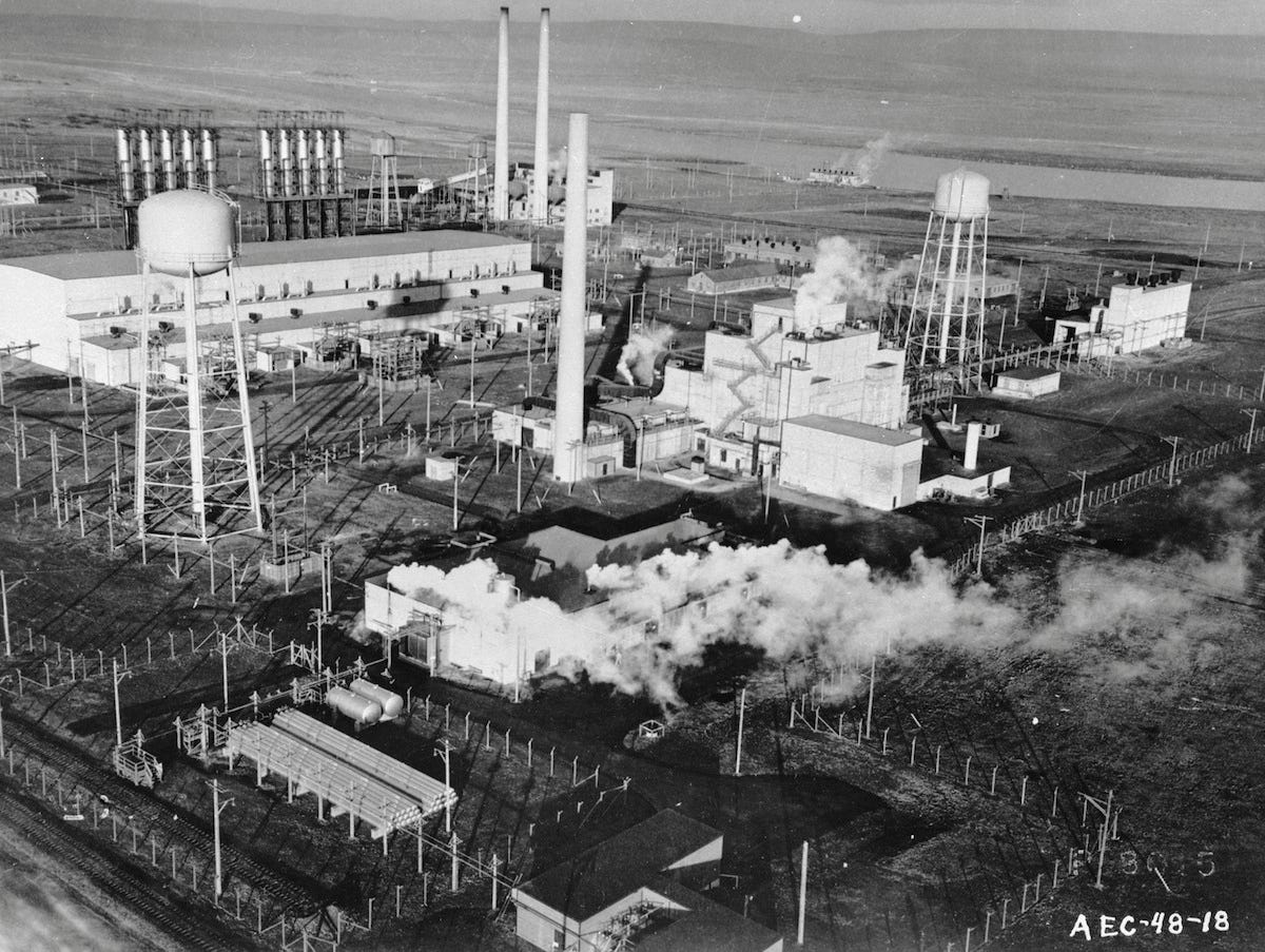
Multiple Proposition 65 listed carcinogenic heavy metals and radioactive biomarkers are detected in concentrations exceeding maximum allowable levels for the reference population including cesium, gadolinium, nickel, rubidium, thallium, copper, manganese, strontium, vanadium, and zinc. All are documented by the Navy and US EPA to be chemicals of concern at HPNS.

Spot maps are used for clusters with a limited number of cases. A dot or X is placed on the location relevant to the disease investigation- most often the address where the subject lives or works. The mapping of small case numbers can be useful in detecting clusters of emerging and rare diseases. The visual display of small cases can prove to be powerful in identifying sources of exposure to hazardous materials.

cholera map
Spot map of cholera cases in Soho, London 1854 by John Snow, MD

John Snow, MD created a spot map of the Broad Street region in London’s Soho neighborhood in 1854 where people and animals lived in  proximity in dirty crowded conditions. Doctors and scientists of the time blamed the outbreak of a new disease that caused severe diarrhea, dehydration and death on “miasma”- bad air.  By mapping cases in the  outbreak, Snow discovered everyone affected had one thing in common…their water source was the Broad Street pump.

On September 18, 1854 Snow removed the pumps handle, ended the outbreak and proved his theory that cholera was a waterborne disease.

John Snow Plaque
Memorial to John Snow

“John Snow’s accomplishments in medicine, anesthesia, and epidemiology constituted an achievement that changed the face of medical practice.“

John Snow, MD: anesthetist to the Queen of England and pioneer epidemiologist.

 Geographic information systems contain data projected as visual displays. Geospatial mapping is an analytical tool capable of generating maps with spatially distributed data. Google maps is a geospatial mapping tool in common use that assigns a single indicator pin to a location on a standard map entered into the location bar of the software program by users.
HP Biomonitoring has relied on manual mappings to create visual displays of chemical and disease clusters detected using urinary screenings, field surveillance and family referrals since it’s launch in 2019.

Parcel E2 & F
A caption for the above image.

Overlapping geographic information systems with cancer and chemical cluster mappings can create easily understandable visual displays of disease distributions in time and space.

GIS mappings are a powerful tool in determining the source of a disease outbreak or chemical exposure.

The Hunters Point Biomonitoring Foundation was awarded a $50,000 grant by CalEPA to create Community Window on Exposure in BVHP. The virtual window will build an integrated website with major environmental geographic information systems (GIS) on the homepage, including the EPA EJScreen, CalEPA EnviroScreen, BVHP IVAN Network and BAAQMD Interactive Maps and live stream data from the AB617 funded Marie Harrison Bayview Air Monitoring network of ten stationary fine particulate sensing Dylos monitors.

Geographic information systems allow investigators to store, analyze, model and display all relevant data. GIS visual displays can  easily understood by non-English speaking residents and students seeking proficiency in environmental science.

Community Window on Exposure will incorporate a digital mapping tool capable of assigning multiple colored indicator pins corresponding to specific chemicals, cancers or diseases to an address or work location. At build out, Community Window on Exposure will support electronic health and laboratory records as a critical first step in establishment of the Hunters Point Community Toxic Registry.

Cluster mapping tools have been developed that visualize and analyze where and why health events occur. CLUSTER is an IBM compatible software program offering researchers a choice of statistical methods to use when investigating clusters. Maptitude software can be used to detect clusters of health events requiring further investigation and analysis. ArcGIS Pro is a tool that performs cluster analysis to identify the location of “hot spots” in an epidemic. 

SaTScan is a free (I like free) software program that analyzes spatial, temporal and space-time data to perform geographic surveillance of disease clusters, test whether a disease is randomly distributed over space and time or perform repeated surveillance for early detection of emerging clusters.

*

According to CDC Guidelines a cluster is a greater than expected number of observed cases for a population similar in age, race or gender in a geographic area. Equally important, the detection of anomalous patterns of disease distribution within the cluster may aide in identifying the source of an epidemic or exposure.

Cluster Map

“The Breast Cancer Necklace” is the eponym HP Biomonitoring  assigned to the pattern of breast cancer cases mapped in women living within the six block perimeter of the federal Superfund system. The cases encircle the perimeter of the base, northeast to southwest,  like a loose string of red pearls - unlike the concentration of radiation induced cancers mapped around the main entry corridor and western fence line of the naval base.

It is one of the most subtle and intriguing findings HP Biomonitoring has uncovered in mapping the pattern and distribution of radiation induced cancers within the one mile perimeter of the federal Superfund system at the Hunters Point Naval Shipyard.

In verifying a cancer clusters all cases must involve the same type of cancer or types of cancer scientifically proven to have the same cause. HP Biomonitoring’s geospatial mapping of radiation induced cancers offers an undeniably significant visual image of radiosensitive cancers of the brain, breast, thyroid, lung and leukemia clustered around the corridor of entry to the US Naval Radiological Defense Laboratories, its radiation contaminated Parcel E-2 shoreline and industrial landfill - a federal Superfund site.

One of every four deaths in the United States is due to some form of cancer making it inherently challenging to identify and interpret cancer clusters. State and local health departments are tasked with responding to a suspected cancer cluster.

Meg McKinley of the California Cancer Registry has agreed to verify the growing cluster of cancers linked to radiation, carcinogenic heavy metals and other Proposition 65 listed chemicals known to be present in the estimated 800 acre system of federal Superfund sites at the Hunters Point Naval Shipyard.

A conundrum is a riddle and the detection of a small strand of pearls in a “Breast Cancer Necklace” encircling the western perimeter of a system of three federal Superfund sites raises questions.

  1. Is the ring like pattern of breast cancer cases encircling the perimeter of a radiation contaminated naval base evidence of exposure to cancer causing chemicals documented to be present there?
  1. Is the ring like pattern of breast cancer cases encircling the perimeter of the southern shoreline possible evidence of airborne transmission of carcinogenic heavy metals and volatile organic compounds?
  1. Or is the ring like pattern simply an artifact created by the distribution of breast cancer cases in a densely populated neighborhood encircling a largely uninhabited naval base?

Ahimsa Sumchai Porter, MD, West Portal, Medical Director Golden State MD Health & Wellness is a longtime neighborhood and environmental activist

APRIL 2022

Demonstration against contamination
The Shipyard Photo: Lennar/Five Point LLC Developers

A Black History Month Special Presentation

CANCER ALLEY …
At Hunters Point Shipyard

Dr. Ahimsa Sumchai
Dr. Ahimsa Sumchai

Seventeen years have passed since demolition, deconstruction, deep soil excavations and grading of the Hunters Point hilltop began to make way for dirty residential development on a federal Superfund site.

Welcome to the unveiling of Cancer Alley at the Hunters Point Shipyard!

film cover
Steph Curry's film on Louisiana's Cancer Alley

Cancer Alley - a documentary produced by Golden State Warrior Steph Curry, follows residents of St. James Parish in Louisiana. Cancer Alley is an 85-mile chemical corridor along the Mississippi River where multiple industrial plants operate. It is home to seven of the ten most cancer ridden census tracts in America.

The Dow Chemical Corporation Union Carbide complex plant emits 4 tons of cancer-causing air contaminants each year in the iconic backdrop of the Holy Rosary Cemetery in St. Charles Parish, Louisiana - where the ancestors of African slaves are interned. A ProPublica analysis released on November 2, 2021, found the Union Carbide plant to be a top emitter of cancer-causing chemicals in Cancer Alley.

On March 2, 2021 the United Nations Human Rights Commission issued a harshly worded condemnation of plans to advance industrialization of Cancer Alley - an 85 mile long chemical corridor along (pix)the Mississippi from New Orleans to Baton Rouge, Louisiana - where 150 petrochemical plants operate and where cancer clusters have been detected for decades that disproportionately burden the descendants of enslaved Africans who labored in the sweltering heat of sugar cane fields.

Cemetary in Louisiana cancer alley
Photo: Giles Clarke

“This form of environmental racism poses serious and disproportionate threats to the enjoyment of human rights of its largely African American residents, including the right to equality and non-discrimination, the right to life, the right to health and the right to an adequate standard of living and cultural rights.”  United Nations Human Rights Office of the High Commission

toxic sites in Louisiana

The EPA National Air Toxics Assessment mapping tool detects cancer clusters in shades of grey centered along the Gulf Coast chemical corridor dubbed Cancer Alley. According to data from the EPA National Air Toxic Assessments map, the cancer risks in the predominantly African American district of St. James Parish averages 105 cases per million in stark contrast with predominantly white districts where cancer risks are comparatively low at 60 per million…but still exceed EPA’s acceptable excess cancer risk of 1 in a million.

In 2018 the St. James Parish Council approved the “Sunshine Project” allowing one of the world’s largest plastics facilities to be sited in Cancer Alley that is projected to boost toxic air emissions and double cancer risks. According to EPA projections the “Sunshine Project” will generate annual carbon dioxide emissions in St. James Parish exceeding 113 countries. 

quote marks

... infant mortality rates in BVHP (were) twice as high as the rest of San Francisco and one of the highest in the state. Statistical analysis found that infant mortality rates in the 94124 zip code matched rates in Jamaica and that the risk of being poor and/or African American did not account for a cluster of infant deaths detected by investigative journalists centered around the shipyards South Basin region”

On March 02, 2021 fourteen United Nations Human Rights experts branded the expansion and granting of pollution permits by government agencies in Cancer Alley “environmental racism.” Many Cancer Alley residents live within feet of unfortified fence lines that offer no buffer zone of safety to nearby homes, schools, playgrounds and churches.
“The African American descendants of the enslaved people who once worked the land are today the primary victims of deadly environmental pollution that these petrochemical plants in their neighborhoods have caused…we call on the United States and St. James Parish to recognize and pay reparations for centuries of harm to Afro-descendants rooted in slavery and colonialism.” United Nations Human Rights Office of the High Commissioner - March 02, 2021

Global Contamination

On October 8, 2021 the United Nations Human Rights Council passed a hard fought resolution recognizing access to a healthy and sustainable environment as a Universal Right.  

The Burgeoning Body Burden of the Earth

Research published in the Journal of Environmental Science & Technology in January of 2022 concludes there has been a fiftyfold increase in the production of chemicals since 1950 and “chemical pollution threatens Earth’s systems by damaging the biological and physical processes that underpin all life.” [Chemical pollution has crossed a planetary boundary, the point at which human-made changes to the Earth push it outside the stable environment of the last 10,000 years.

Louisiana’s Cancer Alley gained a powerful “ally” in 2015 when Lt. General Russell Honore’ joined the fight for environmental health and justice in his home state. According to the CDC, Louisiana ranks at the top of states with high rates of cancer.

Lt. General Russell Honore
Lt. General Russell Honore’

General Honore’ offers a full throated profane analysis of life in Cancer Alley in the powerful YouTube video A Look at Cancer Alley From the Front Lines.

Geospatial mappings conducted by the Deep South Center for Environmental Justice show there is not only a correlation between industrial pollution and the race of residents in nine Louisiana parishes along the Cancer Alley chemical corridor…but that the siting of toxic emission sources increases as the population of African Americans increases.


Demonstration against contamination
Bayview residents protest contamination clean-up efforts at Hunters Point Shipyard

Yet while residents of Cancer Alley face a cancer risk from exposure to toxic air contaminants and chemical emissions 20 times higher than the national average, Louisiana does not place among the Top 10 states with the greatest number of dangerous chemical emitting industrial facilities. With 886 fully operational petrochemical facilities…California does.

ChemicalEmissions

The California Department of Public Health verified eight disease and cancer clusters in the state by 2011. Additionally, independent researchers detected “significantly increased rates of cancer of radiosensitive organs” in population centers adjacent to the nine major nuclear installations in the U.S. that include Lawrence Livermore and Los Alamos laboratories operating under the auspices of the University of California.
   
A disease or cancer cluster is defined by the CDC as a greater than expected number of cases of a disease in a geographic area over a period of time that meets several criteria:

1. The observed number of cases is higher than an observer would expect in a similar population.

2. The cases involve the same type of cancer or cancers known to be induced by the same cause.

3. The population in which the cluster has been detected can be defined by anthropometric factors such as race, age or gender.

4. The geographic boundaries of the cluster can be defined, and geospatial mappings may serve to identify the source of exposure.

5. The observed number of cases in the cluster and the expected number of cases in the population can be calculated over a time-period in which the cases were detected.

Surviving Cancer Alley

According to the Natural Resources Defense Council, Inc (NRDC), the detection of cancer clusters highlights the need to protect people from toxic chemicals by directing federal assistance to state and local health officials to investigate suspected disease clusters and their causes and by eliminating toxic releases through enforcement of strong environmental controls. According to research conducted by the Deep South Center for Environmental Justice, survival in five Cancer Alley communities is most closely linked to community activism, citizen science and scientific literacy.

“A new report claims the Navy’s cleanup efforts at the site of San Francisco’s new $8 billion neighborhood rely on outdated safety standards, equivalent to those used by the EPA in 1991. The cleanup level for Radium 226 - which is responsible for most of the site’s radiological contamination - is nearly 900 times higher than the level permitted by the EPA. These low standards could mean a greater number of workers and future residents face a higher risk of cancer due to the sites residual contamination. “San Francisco’s planned $8 billion neighborhood has a radioactive past, and it may put people at higher risk of cancer than experts thought. Aria Bendix - Business Insider October 23, 2018

Greenaction protest
Grassroots community activism and “Citizen Science” join hands at the Greenaction Protest held on September 2018 at The Shipyard following the discovery of a radium 226 emitting deck marker in a residential community.
contaminated site

It should come as no surprise that disease and cancer clusters have been mapped by the Hunters Point Community Biomonitoring Program and its 501(c)3 public benefit foundation that center around the historic entry to the campus of the United States Naval Radiological Defense Laboratory and its radiation contaminated shoreline and industrial landfill. Along with Yosemite Slough, these heavily contaminated properties comprise a system of three federal Superfund sites. Sandwiched between them at 1212 Thomas Avenue is the Bay Area Drum State Superfund site.

Bayview map

A paper trail of public health research, epidemiological disease tracking, investigative journalism and a string of lawsuits filed against the master developer, offer clear evidence of the existence of disease and cancer clusters within the 94124 zip code and census tracts bordering the Hunters Point Naval Shipyard.

In 1995 lead investigator Dr. Frances Taylor, released a SFDPH study conducted in response to “pleas from the predominantly African American neighborhood. Many residents believe they’re victims of environmental racism, suffering from cancer, asthma and other diseases caused by industrial development that no one else wanted.”

Taylor detected a cluster of breast cancer that included women as young as 20. African American women accounted for much of the excess incidence and mortality.

The 2004 SFGate investigation Too Young To Die, Part One: Life’s Toll, detected infant mortality rates in BVHP twice as high as the rest of San Francisco and one of the highest in the state. Statistical analysis found that infant mortality rates in the 94124 zip code matched rates in Jamaica and that the risk of being poor and/or African American did not account for a cluster of infant deaths detected by investigative journalists centered around the shipyards South Basin region.

SF DPH chart

A SFDPH bar graph compares leading causes of ER visits and hospitalizations in the 94124 zip code with nearby Visitation Valley and San Francisco as a whole. Preventable emergency room visits in 94124 almost double the rate in 94134. The combined majority being cardiopulmonary diseases linked with exposure to toxic air contaminants.


Angela Alioto Law Office
Alioto Law Office - McIntyre case 2008 Photo: Michael Macor / Chronicle

Attorney Angela Alioto represented African American plaintiffs Gary McIntyre and Ceola Richards who charged retaliation by supervisors after they refused to adhere to the “code of silence” Lennar executives demanded from employees as clouds of toxic dust engulfed the Hunters Point community during the grading of 1.2 million tons of serpentinite rock from the Hunters Point hilltop in 2006.

A string of lawsuits filed in Superior Court named Lennar Corporation and subcontractors Gordon N. Ball, Inc and CH2M Hill. Gary McIntyre et al v. Lennar Corp et al was filed on March 16, 2007 by Attorney Angela Alioto - former President of the San Francisco Board of Supervisors - who accused Lennar of “environmental racism” for allowing clouds of toxic construction dust to escape from the shipyard development site “exposing neighbors and school children to potentially harmful airborne asbestos.”

During deposition McIntyre stated that following heavy grading of the Hunters Point hilltop in the Spring of 2006 Lennar refused to shut down work even when air monitors detected asbestos in concentrations triple the state allowance. McIntyre developed symptoms of asthma, skin rashes and hair loss while working as project manager at the shipyard construction site and testified that in a meeting with Lennar executives he was laughed at for his hair loss. Lennar attorneys argued that the construction site was safe despite the issuance of three notices of violation by the San Francisco Department of Public Health and a $550,000 fine by the Bay Area Air Quality Management District. McIntyre et al v. Lennar et al settled in January of 2008.


Grading HP Hilltop
The grading of the Hunters Point hilltop in 2006 - 2007 released an estimated 1.2 million tons of asbestos and heavy metal containing serpentinite rock adjacent to Hunters Point homes, schools and playgrounds. Photo: Liz Hafalia Chronicle
...
Christopher Carpenter

On September 7, 2007 the San Francisco Board of Education voted unanimously in support of a resolution calling for a construction moratorium and independent health assessment at a public hearing in which parents, students, teachers, custodians and school nurses testified to witnessing children and staff with asthma, pneumonia, nosebleeds and headaches triggered by exposure to grading and heavy equipment operations at the Lennar construction site. The unanimously adopted resolution recognized community hero Chris Carpenter.

 Christopher Carpenter was admitted to the hospital in 2006, weeks before his death on March 6, 2016 from a rare cancer of the lymphatic system observed in electrical workers. Carpenters wife underwent biomonitoring screening and appeared in the YouTube video Toxic Land.

A lawsuit filed by Parcel A construction worker Christoper Carpenter in Superior Court in 2008 charged whistleblower retaliation and wrongful termination following a physical altercation with his supervisor over his alleged violation of the “code of silence” expected from shipyard  workers.   

School in Hunters Point
Playground overlooking the shipyard shoreline in Hunters Point Photo: SF Bayview

Carpenter climbed the Hunters Point hilltop to alert teachers at a nearby school after shipyard construction workers were sent home due to dangerous asbestos levels detected by air monitors at the shipyard site. Carpenter worked on Parcel A and lived on nearby Navy Road. He had witnessed numerous dust control violations and testified he was “enveloped in a cloud of dust” at the Parcel A worksite in 2006.

Carpenter died on March 6, 2016 of a rare cancer called peripheral T-cell lymphoma. He is a principle deceased plaintiff for the nine thousand plaintiff Hunters Point Community Lawsuit and is memorialized in the Board of Education Resolution as the “courageous whistleblower” who protected children from exposure to toxic construction dust at the risk of his job… and ultimately his life.

On June 19, 2008, eighteen Hunters Point residents and workers sued Lennar and its contractors in Superior Court acting on behalf of their minor children who suffered headaches, skin rashes and respiratory disease during the Parcel A grading and excavations and legally codified a disease cluster tied to exposure to shipyard toxic dust.


In Marsae Scott et al v. Lennar Corporation et al, a school-aged minor took on the Bay Area’s largest developer. On May 22, 2013 the plaintiffs returned to Superior Court to file an appeal and tort action arising from their “exposure to hazardous substances in dust displaced by defendants during the grading of a redevelopment project. On appeal, plaintiffs argued triable issues of fact exist to support causation of all claims.”

...
John Balmes

Despite three notices of violation for breaches in dust control measures in 2006, a $5500 Bay Area Air Quality Management District (BAAQMD) fine in 2007 and a damning Superior court civil grand jury investigation in 2010, SFDPH “experts” joined UCSF Professor John Balmes to offer testimony on behalf of Lennar Developers against children hospitalized for asthma, pneumonia, headaches and nosebleeds. Balmes was awarded a seat on the California Air Resources Board (CARB) in 2007 and reappointed in 2021 by Governor Gavin Newsom over complaints of African American CARB employees.

In 2019 Balmes issued a public apology to the Bayview Hunters Point Community and an admission that he acted as a paid consultant for Lennar Developers when he issued the statement:

quote marks

It is highly unlikely that exposure to naturally occurring asbestos from grading operations at Parcel A will create a significant risk to human health in the community.” —John Balmes, MD - UCSF Professor of Medicine and Chief Occupational and Environmental Medicine SFGH.

“Hidden Hazards” is a BAAQMD funded research project led by chemist Raymond Tompkins and a team of community investigators. Geospatial mapping of south central BVHP identifies a shoreline community bordering three federal Superfund and a state Superfund site on Thomas Avenue.

The mapping details a cluster of toxic emissions sources overlapping a region of sensitive receptors that include the Southeast Health Center, Bayview Senior Center and two senior housing complexes, private homes, MLK Swimming Pool, Bayview Park, the Bayview Hunters Point Foundation for Community Improvement, 3rd Street Youth Services, Literacy for Environmental Justice, Alice Griffith public housing and a high-volume McDonalds.

Contamination from radiation.
Emission Sources Photo: US Navy

In a letter to San Francisco Mayor London Breed dated March 19, 2019, Tomas Aragon MD, DrPH documented a 31% increase in lung cancer in men in the 94124 zip code derived from an analysis of Greater Bay Area Cancer Registry data for the years 2008 - 2012. The period corresponds to 2,500 anomalous soil samples collected by Tetra Tech workers in a scandal detected by Navy computers in 2012 and traced back to 2008.

Toxic Sign

Geographic Information Systems (GIS) published in Navy remediation documents show 100% concordance between HP Biomonitoring’s geospatial mappings of radiosensitive cancers and the detection of radioactive biomarkers in residents and workers adjacent to radiation contaminated regions of the Hunters Point Naval Shipyard federal Superfund site.

The overlap of the four GIS offers a cause-and-effect visual display that clearly identifies the shipyard as the source of exposure for residents and workers diagnosed with radiosensitive cancers and with Proposition 65 listed cancer-causing chemicals detected on urinary biomonitoring screening.

Geographic information systems (GIS) in Navy remediation documents detail the extent of radiation contamination of the southern shoreline, its industrial landfill and buildings used as laboratories, animal kennels and storage of radioactive materials by the NRDL.

HP Biomonitoring’s visual display of cancer clusters and radioactive biomarker clusters detected on urinary screening shows 100% concordance with Navy documentation of the shipyard shoreline region as a potential source of ionizing radiation exposure. HP Biomonitoring geospatial mappings offer visual proof that radiation induced cancers centered around the shipyards main entry are a secondary health effect of ionizing radiation exposure.

OPEN LETTER
California Department of Public Health and Cancer Registry -01/18/22

“The Hunters Point Biomonitoring Foundation Inc is requesting California Cancer Registry verification of a cluster of cancers linked to ionizing radiation exposure centered around the historic entry to the campus of the Naval Radiological Defense Laboratories at the Hunters Point Naval Shipyard federal Superfund system. These cancers include brain gliomas, thyroid, breast, lung/airway and select skin cancers as well as leukemia and rare lymphomas.

     Many of those diagnosed with cancer have undergone screening using a urinary biomonitoring toxic exposure test processed by a certified laboratory and capable of detecting up to 35 “toxicants.” HP Biomonitoring has detected and verified through repeat screenings carcinogenic and radioactive heavy metals - many of which are listed by the Office of Environmental Health Hazard Assessment as Proposition 65 known carcinogens.

     The Hunters Point Biomonitoring Foundation, Inc is requesting the California Department of Public Health and the California Cancer Registry verify a cluster of cancers known to be induced by ionizing radiation exposure that includes Hunters Point fence line residents and homeowners, clergy, professional women and employees of the San Francisco Police Department and UCSF employees.”


Nick Squires

Nick Squires is the courageous “Citizen Scientist” and former resident of West Hanover Massachusetts who underwent neurosurgery for a rare brain tumor he believes was induced by childhood exposures to cancer causing heavy metals EPA investigations documented to be present at the National Fireworks and Ammunitions company. Squires identified 30 cases of brain cancer among friends and neighbors using social media before returning to the neighborhood where he grew up to map brain cancers and central nervous system tumors among childhood friends and neighbors living within 2 miles of the shuttered industrial site.

At Squires request, the Massachusetts Cancer Registry reviewed data for census tracts in Hanover and verified “statistical elevations in the incidence of invasive and benign brain and central nervous system tumors from 2006 to 2015 but “did not detect spatial distributions linking the cluster to the suspected source of exposure.” 

Investigations conducted by the EPA at the site of the fireworks and ammunition company detected elevated concentrations of arsenic,  carcinogenic heavy metals, volatile organic compounds and PCB’s…all  proven to induce cancer.

“Shockingly high levels of radioisotopes were detected in  homes and in the tissues of a young woman who died of cancer.”  Marco Kaltofen - President Boston Chemical Data Corp

Mara Hatfield
Attorney Mara Hatfield displays a geospatial mapping of the cancer cluster verified by state health officials. Hatfield represents the parents of children with brain tumors diagnosed in Acreage, Florida. Almost ten years after it was filed, the Acreage cancer cluster lawsuit went to federal court in January of 2022 to prove the aerospace corporation Pratt & Whitney negligently disposed of cancer causing chemicals detected in groundwater, canals, homes and in the tissue of a young woman who died of cancer.

The pattern of brain and central nervous system tumors mapped by Nick Squires in West Hanover and Jennifer Dunsford in Acreage, Florida form a diffuse pattern more consistent with a contaminated drinking water source than airborne transmission.

Acting under the leadership of Florida Governor Charles Crist, the state health department verified the cancer cluster and detected new cases. Environmental testing conducted by state agencies detected Radium 226 in drinking water. Thorium, uranium and thoriated nickel were ultimately detected.


The Understanding of Consequences

...

The cluster of radiosensitive cancers detected by HP Biomonitoring meets all CDC criteria for a disease cluster and centers around the source of exposure…the entry to the campus of a radiation laboratory located on a radiation contaminated shoreline within feet of a radiation contaminated industrial landfill and a dense residential community.

HP Biomonitoring’s up-to-date geospatial mapping of cancers induced by ionizing radiation exposure at the Hunters Point Naval Shipyard federal Superfund submitted to SFDPH Senior Environmental Health Inspector Humberto Quinonez on January 14, 2022 and to Kathleen Davidson-Allen, Director of the California Cancer Registry on January 18, 2022.

The submission included urinary screenings that detect Proposition 65 listed radioactive and cancer-causing heavy metals cadmium, nickel, cesium, thallium, platinum and tungsten in floridly toxic concentrations in fence line residents diagnosed with brain cancer, breast cancer and acute leukemia.

Urinary screening for toxics
Urinary screening conducted on Hunters Point southern shoreline homeowner diagnosed with acute myeloblastic leukemia and basal cell skin cancer and given weeks to live.

Unlike cancer clusters verified by state health departments in Florida and Massachusetts and by the California Department of Public Health in eight state locations, HP Biomonitoring has photo and video archives and eye- witness testimony of deep soil excavations and heavy equipment operations being actively conducted at the shipyards radiation contaminated landfill and shoreline region within feet of a “naked” western chain metal fence adjacent to homes and public housing,  schools and daycare centers, playgrounds and basketball courts, churches and community centers.

excavation

Deep soil excavations actively conducted in the region of the Parcel E-2 industrial landfill within feet of the unfortified chain metal fence separating a system of three federal Superfund properties from nearby residents. Building 815 on the right was main headquarters of the Naval Radiological Defense Laboratories from 1955 - 1969 and Buildings 830 and 831 - north of heavy equipment operations at the landfill houses approximately 30 UCSF employees. A recent UCSF scoping survey detected cesium, radium, thorium, uranium and progeny in open land areas at Building 831.

The Hunters Point resident and photographer has lived near the western fence at Revere and Fitch for over 20 years. As depicted, the fence line lacks dust barriers and no active dust control measures are in place at the backhoe excavation captured by the resident’s photo.

The fence line resident requested urinary screening that detected multiple dangerous chemicals listed by the State of California under Proposition 65 including arsenic, cesium, nickel, thallium and uranium. A repeat screening was conducted documenting worsening exposures to contaminated shipyard soils and new detections of lead, cadmium and strontium in toxic concentrations.


The Fierce Contagiosity of Courage

Never Surrender

Never Surrender

From the Deep South to the Gulf Coast. From Acreage Florida to Flint Michigan. From West Hanover Massachusetts to the Santa Susana Field Laboratory in San Bernardino County, California. From Cancer Alley Louisiana to Cancer Alley at the Hunters Point Shipyard, communities find hope, inspiration and the strength to stand tall and face off against government silence and corruption, corporate greed, environmental racism and toxic genocide through the contagiosity of courage fueled by grassroots environmental activism and citizen science.

On February 5, 2022 the Hunters Point Biomonitoring Foundation was awarded a $50,000 Environmental Justice grant to implement Community Window on Exposure - a project that will advance the establishment of the Hunters Point Community Toxic Registry.

Ahimsa Sumchai Porter, MD, West Portal, Medical Director Golden State MD Health & Wellness is a longtime neighborhood and environmental activist

February 2022

Tsumani at Golden Gate Bridge
A 250 foot tsunami surges toward the Golden Gate in the 2015 movie San Andreas Photo: Warner Brothers

It’s hard to envision the glistening shoreline when you are being pounded full frontal by the surging waves of a global “tsunami” but a public health movement was launched in the Journal of the American Medical Association on Thursday, January 6, 2022 by six “rogue” advisors to President Biden. In a three part statement the public health experts concede the goal is not to eradicate COVID-19 but to accept — as national strategy — the “new normal” of life with COVID as even the fully vaccinated are being infected by the latest wave of the omicron mutation.

Human Biomonitoring for Enhanced Immunity!

The Neverending Endemic Pandemic

Dr. Ahimsa Sumchai
Dr. Ahimsa Sumchai

Is it still the President’s goal to defeat the virus … or is he coming around to accepting that the virus is going to be a part of life from here forward, that it’s going to become endemic?” Question to Jen Psaki — White House Press Briefing January 6, 2022

“The US needs a comprehensive, digital, real-time, integrated data infrastructure for public health. As Omicron has reemphasized, the US is operating with imprecise estimates of disease spread, limited genomic surveillance, projections based on select reporting sites and data from other countries that may not be generalizable. These shortcomings are threatening lives and societal function.” Journal of the American Medical Association

The bottom line is that it’s not going away, Folks! It will never be the same again and there’s no going back home to “the way we were.” The War on Covid in San Francisco…like the War on Drugs in the Tenderloin, will fail if the strategy is the eradication of the public health threat rather than rebuilding the public health response and societal safety net.

Successive tidal waves pack a punch and in “The City by the Bay” where 81% of residents are fully vaccinated and 54% have received boosters, the strain on hospitals and the 911 system by non-emergent calls is being felt as teachers threaten sick-outs demanding districts enact strict COVID — 19 precautions. San Francisco’s COVID-19 case rate tripled from 91 cases to over 273 by Christmas of 2021 after detecting the first case of Omicron in the U.S on December 1st.

quotes

Natural immunity is not enough to reduce hospitalization and death from exposure to a more virulent or transmissible strain and “real”experts agree natural immunity is not as potent as acquired immunity through vaccination — and that both wane over time leading to risk of reinfection. Natural immunity can decay within 90 days of being infected by COVID-19 while acquired immunity through vaccines like Moderna can last for well over six months”

“The total reported last week was the highest of the pandemic.” New York Times Interactive

According to the New York Times updates as of January 9, 2022 San Francisco County cases were “extremely high” with a total of 78,152 cases and 690 deaths. The daily average of new reported cases was 1,461 … up by 263%!

Covid Usurge in SF
“Pollyanna”-like reassurances by Mayor London Breed that the impact of the highly infectious omicron variant has been “minimal” are refuted by the fact that over 300 San Francisco employees are now quarantined due to COVID exposure including 167 police officers, 135 Fire Department personnel and 85 municipal transportation employees."

The CDC continues to find severe illness, hospitalization and death from Covid 19 rare among those who are fully vaccinated and boosted but urges those over 65 or with a weakened immune system or underlying health conditions to take precautions to prevent contracting infection by new variants.

The World Health Organization declared on January 7, 2022 that the omicron variant is not “mild” and issued a warning of a “tsunami” of COVID cases.

Chart showing surge in cases
New data shows next several weeks critical in beating back COVID-19 surge and protecting SF’s essential services

According to SFGOV, as of December 27, 2021 an average of 829 San Franciscans a day are contracting COVID — 19, “raising the prospect that frontline workers could become infected and temporarily unable to work, impacting SF’s delivery of essential services.”

“This biggest surge yet is taxing our cities in new ways, even more so than delta, Director of Health Dr. Grant Colfax said. The new omicron variant is forcing us to learn to manage and live among COVID while keeping our hospitals and clinics, schools, businesses and many other essential services operating.”

To make matters worse, Bloomberg News reported on January 8, 2022 that Leondios Kostrikis — Professor of Biological Sciences at the University of Cyprus has discovered “Deltacron” — a coronavirus strain that combines the more deadly delta variant with the highly transmissible omicron variant. Kostrikis and his team detected 25 cases of infection due to this ominous COVID — 19 variant in which omicron genetic signatures are detected within the delta genome. Statistical analysis shows Deltacron incidence was higher in patients who required hospitalization.

The Politicalization of Natural Immunity

In crudest terms, when you have immunity to a viral infection it means your body recognizes it as a “foreign invader” and is able to fight it off. Terms like natural and acquired immunity have been tossed around for the last two years with increasingly more “nebulous” meaning. In pre-COVID basic epidemiology, natural immunity was defined as resistance to reinfection by a virus due to a heightened immune response triggered by the prior infection. In the pre-COVID era it was presumed the virus would ultimately be extinguished when it ran out of people to infect.

Natural immunity is not enough to reduce hospitalization and death from exposure to a more virulent or transmissible strain and “real”experts agree natural immunity is not as potent as acquired immunity through vaccination — and that both wane over time leading to risk of reinfection. Natural immunity can decay within 90 days of being infected by COVID-19 while acquired immunity through vaccines like Moderna can last for well over six months.

Traditional arguments hold that populations eventually reach heightened immunity against COVID — 19 severe disease, hospitalization or death through a combination of natural and acquired immunity through vaccination. This is called “herd immunity” or endemicity. Many experts predicted COVID — 19 will ultimately smolder and become endemic with episodic and seasonal flares...like the flu and common cold. They foretell of a future of human/virus symbiosis in which the pandemic does not end and the virus does not disappear but “enough people will gain immune protection from vaccination and natural infection such that there will be less transmission and COVID — 19 — related hospitalization and death, even as the virus continues to circulate.”

But in the words of ER doctor Hilary Fairbrother, “The idea of natural immunity is not really panning out with this virus.” Part of the problem is that COVID — 19 has so many mutations that vary in transmissibility and severity. As the U.S. averages over 500,000 new cases a day even experts question whether herd immunity can be achieved. While the omicron variant is still able to evade the protection of a three dose vaccine regimen, those reinfected have a milder disease.

Another major part of the problem is the role partisan politics plays in acknowledging the limitations of natural versus acquired immunity in a quixotic quest to eradicate the virus ... and keep Wall Street rolling. An issue that is highly politicalized and bipartisan. President Biden doubled down last week on his plan to “Beat COVID — 19” and publically disagreed with six top advisors saying “I don’t think COVID is here to stay.”

Meanwhile, Republican lawmakers in Indiana and Wisconsin added natural immunity clauses to vaccine exemption bills that allow businesses to accept proof of natural immunity instead of vaccination or coronavirus testing. The Supreme Court will hear arguments on lawsuits challenging Biden’s vaccine mandate for all businesses with over 100 employees

Train Like An Athlete! — Enhanced Immunity Through Human Biomonitoring

“Many professional and Olympic-level athlete settings comprise comprehensive sports medicine and sports science support services, with an objective of:(1) achieving the highest possible level of performance with the lowest number of days lost to injury or illness and (2) a duty to care to protect athletes from long term negative health consequences of their sport. This includes the use of biomarkers to assess the efficacy of training interventions, inform nutritional strategies and assess the capacity to tolerate training loads.” Blood Biomarker Profiling and Monitoring for High-Performance Physiology and Nutrition.

Biomonitoring

I would like to offer my educated “two cents”about the role of “enhanced immunity” with support from a body of medical research little known to the public at large. There is a wealth of information being stockpiled in the sports performance arena about the role of human biomonitoring and biometric tracking systems to promote an enhanced and augmented nutritional, physiological and immune response in elite, high functioning athletes. The fundamental determinants of disease expression are nature and nurture…genetic and controllable environmental influences. In my opinion the best approach to optimizing your natural resilience and immunity during a neverending global pandemic is to TRAIN LIKE AN ATHLETE!

Like a fine tuned automobile, “Top Tier” fuel equates to “Top Tier” performance for the human biomechanical machine. ATHLETE is a consortium of researchers from the US and 11 European countries in partnership with 22 public and private research groups designed to understand and prevent health effects from environmental hazards starting from the earliest stages of life. The human exposome studies the myriad of environmental exposures ( urban, chemical, dietary, lifestyle and social) accrued in our lifetimes to improve health and create a shift toward a more comprehensive and holistic approach. ATHLETE is a project of the European Human Exposome Network — the worlds largest research collaboration studying the impacts of environment exposure on human health.

...
Dr. Sumchai became certified as a sports nutrition consultant following completion of course work at City College Fort Mason Campus in 2001.

One of the most common applications of biomonitoring in elite athletes is to evaluate nutrient status and the ability to manage lactate build up in muscle that limits performance. Salivary tests for the stress hormone cortisol are performed coupled with strategies for feedback loop control through relaxation methods. The Hunters Point Community Biomonitoring Program urinary screening detects the status of essential nutrient elements including iron, copper, calcium, magnesium, potassium, selenium, sulfur and zinc that are required for physical strength, muscular endurance and to optimize immune and thyroid function.

quotes

According to doctors working with Olympians and the National Collegiate Athletic Association, sleep is one of the most important training habits for mental and physical health. LeBron James averages 12 hours of sleep nightly and takes a nap before each game.”

In biomarker profiling and monitoring for high performance physiology and nutrition, Pedlar et al detail the routine use of human biomarker monitoring in professional and high performance testing as a source of “robust research evidence” to identify iron, vitamin or energy deficiency, oxidative stress and inflammation and the status of red blood cells. Serial monitoring can be used to optimize nutritional and immune status and build the capacity to tolerate a high training load.

Vitamins, nutrients and foods statistically linked to improved athletic performance include iron, probiotics, Vitamin D, creatine, caffeine and select minerals.

Biomonitoring research on elite athletes has yielded findings to support the essential role of sulfur in cartilage and collagen synthesis, growth, metabolic processes, defense and detoxification. Sulfur is present in all cells and a shortage of sulfur is linked to physical fatigue, muscle injury and loss of lung elasticity.

Additionally, there is a bounty of research on the healing and restorative role of sleep. According to doctors working with Olympians and the National Collegiate Athletic Association, sleep is one of the most important training habits for mental and physical health. LeBron James averages 12 hours of sleep nightly and takes a nap before each game. Adequate sleep enhances immune function, reduces risk of upper respiratory tract infections and risk of injury. Muscle injury repair, growth, alertness, stamina and cognitive function are enhanced by the universal human requirement for sleep.

The training habits of elite athletes can serve as models of success and beacons of inspiration when examining optimum diets, training schedules and techniques used to optimize peak performance and physical conditioning.

Gratitude

I am so “over” reacting like a lab rat in a maze of confusion to the latest surge of the most recently mutated “flavor of the month” COVID — 19 variant and the secondary fallout and contradictory health messages!

Instead, I enjoy wearing my mask … it is my closest friend. It keeps my face warm in the cold of winter and rebreathing carbon dioxide helps reduce the neverending anxiety triggered by life in a global pandemic.

I have learned to enjoy and appreciate physical distancing. I was never comfortable having strangers come up to me to pet my dog and ask if I am dating.

Whether it be by blessing or design, I am most grateful that I can say neither I nor any member of my immediate family has tested positive for or been diagnosed with any COVID — 19 infection in the two years of the everlasting pandemic and I credit it to a safe environment and healthy nutrition. In the words of Hippocrates, “ Let food be thy medicine and medicine be thy food.”

my grandaughters
My granddaughters Karah (l) and Legacy (r), like all members of my immediate family have not been infected with COVID — 19

Life in the New Normal

“Without a strategic plan for the “new normal” with endemic COVID — 19, more people in the U.S. will unnecessarily experience morbidity and mortality, health inequalities will widen, and trillions will be lost from the U.S. economy,” wrote Dr. Ezekiel Emanuel, Dr. Michael Osterholm and Dr. Celine Gounder — members of Biden’s COVID-19 Transition Advisory Board in 2020. The public health experts wrote in JAMA that rather than “living in a perpetual state of emergency,” the public should coexist with the virus by mitigating outbreaks and practice “humility” in contending with an enduring endemic neverending pandemic.

Ahimsa Sumchai Porter, MD, West Portal, Medical Director Golden State MD Health & Wellness is a longtime neighborhood and environmental activist

January 2022

...
EPA Administrator Michael Regan “Let me be clear…I know that we have to rebuild trust. I know that this didn’t happen overnight and won’t be resolved overnight. So our commitment is to do better, leverage our enforcement, work with Congress to get the toughest laws in place that are adequate and protective…and to do this in concert with community members who have been advocating this for decades.” Residents of Louisiana’s Cancer Alley hopeful for action after EPA head’s visit AP Photo/Nic Coury

Environmental Justice

Signed…Sealed…and Delivered!

EPA reveals that pollution is unequally distributed across the United States into clusters known as “sacrifice zones"

Environmental justice is on the way to the “Cancer Alleys” and “Sacrifice Zones’ of the United States. EPA Administrator Michael Regan launched his “Journey to Justice” tour and pledge to “ hold everyone accountable” on November 17, 2021. Regan was warmly welcomed by residents of Reserve, Louisiana where the risk of cancer is 50 times greater than the national average and the highest in the country. Toxic air pollution from a petrochemical plant built on the site of a former plantation is blamed for emitting over 50 chemicals above a community in the heart of “Cancer Alley”- an 85 mile stretch along the Mississippi River thronged with oil refineries and chemical plants and where most households includes a relative who has died from cancer. [https://www.theguardian.com/us-news/video/2019/may/03/reserve-louisiana-cancertown-video]

Poison in the Air

ProPublica — a non profit newsroom that investigates abuses of power created a first-of-its-kind map and data analysis of “Sacrifice Zones”- where residents breath carcinogens in toxic air emissions from polluting industries. Using advanced data processing and modeling tools developed by the EPA, Propublica undertook an analysis of the location of the nations Sacrifice Zones where air pollution from industrial plants is increasing cancer risks for an estimated quarter of a million Americans to unacceptable levels.

In response to ProPublica’s findings the EPA’s Office of Air and Radiation issued a statement acknowledging “Toxic air emissions from industrial facilities are a problem that must be addressed. Under President Joe Biden’s administration the EPA has reinvigorated its commitment to protect public health from toxic air emissions from industrial facilities in communities suffering disproportionately from air pollution and environmental burdens.”

Census tracts where the majority of residents are people of color experience 40% more cancer causing toxic air contaminants than census tracts that are predominantly white. The major Sacrifice Zone of cancer causing petrochemical emissions in the San Francisco Bay Area are the Martinez and Richmond oil refineries.

Refinery
View of the Martinez Refinery in Martinez, California on April 27, 2020. Photo: Jose Carlos Fajardo/Bay Area News Group

On January 20, 2021 by the authority vested in the President by the United States Constitution, Joseph R Biden, Jr issued the White House Executive Order on Protecting Public Health and the Environment that embodies the fundamental policy that:

“Our Nation has an abiding commitment to empower our workers and communities; promote and protect our public health and the environment; and conserve our national treasures and monuments — places that secure our national memory. Where the Federal Government has failed to meet that commitment in the past, it must advance environmental justice.”

President Biden
President Joe Biden announcing his administration’s environmental and energy team on January 27, 2021 Photo: Kriston Jae Bethel for the New York TimesStory Here
quotes

The Parcel E-2 landfill is a federal Superfund site known to contain irradiated animal carcasses, radium dials and radioactive sand blast...its shoreline is an earthquake liquefaction zone and highly susceptible to rising sea levels. The Navy is preparing to transfer Parcel E-2 to the City for open space development.”


Sammy Johnson

Sammy Johnson.
10 year old Sammy Johnson died in his mother’s arms of a rare cancer of the brainstem induced by exposure to radiation and carcinogenic heavy metals on September 20, 2021. Sammy was the only son of Nia and Eric Johnson who live less than a mile from the federal Superfund site at the Hunters Point Naval Shipyard.

Investigative Journalist Carol Harvey chronicled Sammy’s life and death in the SF Bayview.

Samuel Ace Johnson was 10 years old on Monday, September 21, 2021 when he died in his mother’s arms with his father at his bedside in the family home - a mile west from the Crisp Road entry to the federal Superfund system at the Hunters Point Naval Shipyard.

Sammy was a San Francisco Giants fan in February of 2021 when his mother Nia Johnson left work as an LVN to devote full time attention to his care after he was diagnosed with a terrible childhood cancer called diffuse intrinsic pontine glioma (DIPG) that handed him a “death sentence” and nine months of survival.

Sammy Johnson's family
Sammy Johnson wrapped in the “ginormous” love of his parents Nia and Eric at the 2014 Giants World Series Championship Trophy - AT&T Park in San Francisco.

There is no effective treatment for DIPG and no chance of survival. DIPG is a rapidly invasive and infiltrating cancer in a vital region of the brainstem that controls breathing, balance, swallowing, heart rate and blood pressure.

According to the American Cancer Society the most established risk factor for brain tumors is radiation exposure.

DIPG-diffuse-intrinsic-pontine-glioma
DIPG may respond temporarily to targeted radiation therapy but it is highly aggressive and infiltrates an area of the low the brainstem called the pons that controls vital functions including breathing, heart rate and blood pressure.

Recent research shows the brain is very sensitive to ionizing radiation and a child’s brain is more radiosensitive than an adults. The majority of brain tumors in children occur in the brainstem and their incidence in the US has dramatically increased possibly due to improved detection. Glioma is the most common childhood brain tumor in 47% of cases.

Brainstem Glioma
Brainstem glioma in a child detected on MRI scan compressing vital structures in the narrow tunnel between the base of the skull and upper cervical spine that control breathing, swallowing, movement, heart rate and blood pressure

An aggressive high grade glioma can double in size in seven weeks and radiation induced gliomas in children have been detected with a latency less than five years following exposure to ionizing radiation.

Five carcinogenic heavy metals have been shown to induce brain cancer in laboratory animals. Arsenic, beryllium, cadmium, chromium and nickel are classified as Group 1 Carcinogens by the International Agency for Research on Cancer.

Cancers of the brain, head, neck, breast and respiratory system are linked to air borne exposure to toxic pollutants by the World Trade Center Health Program.


Superfund Sites
The U.S. Environmental Protection Agency recently announced it added seven hazardous waste sites to the National Priorities List of Superfund Sites…Superfund is the federal program that investigates and cleans up complex, uncontrolled or abandoned hazardous waste sites in the country… The added sites include former mine, steel, metal finishing and landfill sites. The EPA also changed the name of the former Treasure Island Naval Station — Hunters Point Annex site in San Francisco, California to the Hunters Point Naval Shipyard.
Superfund National Priorities List Sites Where You Live — Overview

The CDC defines a cancer cluster as a “greater than expected number of cancer cases occurring within a group of people in a geographic area over a period of time.” The lifetime risk of developing brain cancer is 0.6% according to the American Cancer Society. Brain tumors offer a unique marker for environmental disease because they are so rare. When even a small cluster of cases is detected in spatial relationship to a known source of ionizing radiation the statistical significance is irrefutable. [Searching for the Roots of Brain Cancer]

Map of cancer incidents
The Hunters Point Biomonitoring Foundation Geospatial mapping of a cancer cluster linked to ionizing radiation exposure in residents and workers within a one mile buffer zone of the federal Superfund system at the Hunters Point Naval Shipyard and adjoining Yosemite Slough. Cases detected from 2010 to current. Pin colors correspond to following key: yellow: brain and central nervous system, red: breast, green: thyroid, white: leukemia, lymphoma and haematopoietic, blue: lung & airway, gold: pelvic, colon, reproductive, black: canine/feline cancer deaths

Sammy Johnson
Little Sammy Johnson lives on as a yellow pin posted in a cluster of brain tumors detected one mile west of the Crisp Road entry to the federal Superfund site at the Hunters Point Naval Shipyard and it’s radiation contaminated Parcel E-2 shoreline and industrial landfill
Go FundMe help for Sammy's family

The Parcel E-2 landfill is a federal Superfund site known to contain irradiated animal carcasses, radium dials and radioactive sand blast. Methane gas in concentrations as high as 60% in air is detected by the Navy in late summer. The Parcel E-2 shoreline is an earthquake liquefaction zone and highly susceptible to rising sea levels. The Navy is preparing to transfer Parcel E-2 to the City and County of San Francisco for open space development.


In the Dark of the Valley
In the Dark of the Valley is a feature film about the Santa Susana Field Laboratory, a former nuclear and rocket-engine testing site near Los Angeles that aired on MSNBC on Sunday, Nov. 14, 2021. The film is an in-depth exploration into the site’s long history of cover-ups and negligence by the site owners, Boeing, NASA and the Department of Energy. It details the courage of people exposing the truth about the Santa Susana Radiation Laboratory, site of one of the largest nuclear accidents in U.S. history in 1959. It also tells the harrowing story of how a community of mothers, led by Melissa Bumstead, have dealt with the struggles of childhood cancer and their new found life of environmental advocacy. She is a Southern California mother who lives 7 miles downhill from the site of a radiation meltdown concealed from the public for 20 years and never remediated. It features Dr. Bob Dodge and Denise Duffield of PSR-Los Angeles

The Santa Susana Field Laboratory (SSFL) was hidden in the hills above the San Fernando Valley. In Area IV of SSFL a stealth collaboration operated between the US Department of Energy, NASA and Boeing to research the “outer limits” of nuclear power. According to LA’s Nuclear Secret, “Years of mishandling dangerous radioactive waste materials and chemicals also left a toxic legacy for generations of people living near the Santa Susana Field Laboratory.”

The feature film centers on the fierce maternal protectiveness of a community of mothers whose children have been diagnosed with cancer. It documents a cluster of childhood brain cancers that include two children on the same city block with the same rare form of brain cancer.

“They were shocked to hear the health officials explain that the community was definitely experiencing a cluster of pediatric brain tumors, as well as elevated rates of all cancers at all ages.”

Cancer Parents protest.
Angry residents of the South Florida town Acreage at a 2010 community hearing where a cluster of childhood cancers detected by Jennifer Dunsford included four children with brain cancer living within two miles of a fireworks and munitions company. A state investigation validated existence of the cluster but did not hold the polluter accountable. Photo: Gary Coronado The Palm Beach Post

Radium 226 contaminated the drinking water of the South Florida town of Acreage. It took years for the families of children with cancer to connect the dots but by May of 2009, Jennifer Dunsford had constructed a database documenting dozens of cancers in Acreage and had notified the state health department. Jennifer Dunsfords’ five year old son Garrett underwent brain surgery that left his left arm paralyzed.

“When Becky heard from a friend that another child in the neighborhood had recently been diagnosed with a brain tumor, “I was like: what is going on?” Just after Hannah underwent surgery to remove her tumor, and less than a year after the boy — a 5 year old named Garrett Dunsford — had his brain surgery, the parents started talking.”

Only one in 40,000 children in the US is expected to develop a brain tumor each year. In Acreage -a town of 39,000 people- the investigation turned up 13 brain tumors between 1994 and 2007. The Florida Department of Health concluded the risk of a girl in Acreage developing a brain tumor was five and a half times higher than the rest of Florida. The Health Department investigation found children with cancer living 1,000 feet apart from one another.

A joint agency environmental investigation led by Governor Charlie Crist was conducted by the CDC, State and Palm Beach County Health Department and the Florida Department of Environmental Protection. The agencies tested well water and soil from thirty five homes for over 200 chemicals. Several contaminants were detected above EPA cleanup levels including radium 226, benzene and a host of common carcinogens. The contamination that distinguished Acreage most was ionizing radiation because it is an established cause of brain cancer and a byproduct of local industry.


Brain cancer survivor Nick Squires holds a map of brain cancer cases in his West Hanover neighborhood in 2019. Squires tracked brain tumor cases among his neighbors that prompted a Massachusetts state review that confirmed statistical elevations in brain and nervous system cancers in three census tracts from 2006–2015.


Conclusively blaming a chemical culprit for a cancer cluster is so difficult that only three of 428 cluster investigations conducted in the United States since 1990 have established a link between pollution and illness.” Cancer Clusters in the USA: What do twenty years of state and federal investigations tell us?

The Massachusetts Department of Public Health Bureau of Environmental Health released findings of a review of the incidence of brain cancers among residents living within 2 miles of the former National Fireworks Company site in West Hanover. The state investigation validated the pioneering work conducted by brain cancer survivor Nick Squires in confirming “statistical elevations” in the incidences of invasive or benign brain and nervous system cancers in three census tracts from 2006 to 2015. The state investigation detected 36 cases of brain tumors compared with an expected 24. However, the state investigation failed to find a spatial distribution linking the brain cancer cluster to carcinogenic heavy metals known to contaminate the National Fireworks Company site. In 1980 the federal EPA found barrels of toxic waste dumped on the property containing arsenic, chloroform, trichloroethylene and vinyl chloride.

According to the March 31, 2021 Patriot Ledger, “The National Fireworks Co. began developing, testing and manufacturing civil fireworks and military munitions at the site near the Hanson town line in 1907 and disposed of chemicals there until it closed in 1971…A variety of heavy metals were found in the soil and water around the former factory, setting off a decades long effort to clean up an area where contamination measured at twice the threshold for earning Superfund status.”


plutonium production plant
How the Atomic Age Left Us a Half-Century of Radioactive Waste. Photo of the Atomic Energy Commissions plutonium production plant at Hanford, Washington, Circa 1955. Photo: Evans/Getty Images

Decades of population research has established a decisive link between central nervous system cancer clusters and nuclear waste sites. An international journal review of cancers among residents downwind of the Hanford Plutonium Production site in southeastern Washington State detected cases greater than expected for the population. In 1943 Hanford produced the “Fat Man” plutonium bomb dropped on Nagasaki on August 9, 1945 and the Operation Crossroads bombs detonated in the Bikini Atoll in July of 1946.

Fat Man plutonium bomb
Declassified National Archives Photo — A technician applies sealant and putty to the crevices of a “Fat Man” plutonium bomb.

The former Hanford plutonium plant is the largest nuclear clean-up site in the western hemisphere costing taxpayers a billion dollars a year. A community based health survey of 800 residents conducted between 1944 and 1995 revealed high incidences of all cancers including brain and thyroid.

“There were greater than expected numbers of central nervous system cancers and the authors argue the greater than expected numbers cannot be accounted for by selection bias alone.”

Map of Superfund density adjusted cancer clusters in the US
Map of Cancer Cluster density adjusted cancer clusters in the US identifies northern California cluster

A spatial study of the location of Superfund sites and associated cancer risks addressed three main research questions about geographic locations selected for listing by the U.S. EPA as having extreme toxic chemical contamination. The questions posed are:

  • Are there geographical areas where the number or density of Superfund sites is significantly higher than in the rest of the US?
  • Is there an association between cancer incidence and the number or density of Superfund sites?
  • Do counties with Superfund sites have higher minority populations than the rest of the USA.

The answer to all three questions is a resounding yes! Using the advanced disease surveillance software program SaTScan capable of identifying locations and risks of spatial clusters in cancer rates and Superfund site density the authors conclude:

“We find that geographic areas with Superfund sites tend to have elevated cancer risk, and also elevated proportions of minority populations.” Raid Amin, Arlene Nelson & Shannon McDougall — Tandfonline.com, Statistics and Public Policy

Hunters Point Danger Sign
Surgicle scar

Working in a Wasteland

In a 2018 photo published in the San Francisco Chronicle, Tony Montoya — President of the Police Officers Association — displays a surgical scar vertically aligned along the posterior region of his skull and upper cervical spine. It is the approach most often used by neurosurgeons requiring emergency access to compressing tumors of the brainstem. Montoya served as a K-9 officer in Building 606 from 2005–2008 located on the southeast shoreline of the Hunters Point Naval Shipyard at the border of Parcel E and Parcel D. Building 606 is the site of a cluster of brain, lung, thyroid and canine cancers.


Pathways of Exposure: Yosemite Slough

Yosemite Slough
A 32 year old physical therapist grew up on Yosemite Avenue adjacent to Yosemite Slough — a muddy channel of water that carries sediment from the shipyards contaminated Parcel E-2 shoreline west towards 3rd street. She developed right sided weakness and imbalance that caused her to repeatedly sprain her ankle underwent MRI scan that detected a brain stem glioma. After undergoing 30 rounds of RT in three weeks her symptoms worsened due to swelling in her brain but ultimately she moved on with her life and her career. She requested a urinary toxic exposure screening that detected a “slough” of cancer causing heavy metals in elevated concentrations including the Group 1 carcinogens nickel and cadmium.Photo: Ahimsa Porter Sumchai, March 20, 2020
Toxic Chart
Urinary toxic exposure screening conducted by HP Biomonitoring on a 32 year old woman diagnosed with a brainstem glioma who grew up adjacent to Yosemite Slough and currently resides on the Hunters Point hilltop north of the shipyard Crisp Road main entry to the Parcel E-2 shoreline. Multiple heavy metals are detected in elevated concentrations including the Group 1 Carcinogens cadmium and nickel. Aluminum Gadolinium, Copper, Iron, Manganese, Molybdenum and Vanadium and detected in concentrations far exceeding the normal population.
Children's Playground
Children’s playground located in the 1000 block of Palou at the Crisp Road entry to the federal Superfund site a within 500 feet of the radiation contaminated Parcel E-2 shoreline. A Youtube video created by the author and photographer captures Proposition 65 Dust Barrier Violations and breaches in the fence line separating deep soil excavations can be viewed here.
Grace Tabernacle
The Bishop  of a church in the 1100 block of Oakdale located 500 feet west of the fence line separating the federal Superfund site from the church built by his father was diagnosed with two brain tumors different brain tumors—including a brainstem glioma. A Youtube video captures Proposition 65 fence line violations
Toxic Chart
Elected member of the Hunters Point Shipyard Restoration Advisory Board and 20 year homeowner and artist located in the 1200 block of Oakdale west of the Crisp Road entry to the Hunters Point Naval Shipyard has undergone brain surgery twice for meningiomas — a type of brain tumor linked to ionizing radiation exposure. Her urinary screening detects cesium, gadolinium, nickel, rubidium, thallium, manganese, strontium, and vanadium above reference range for the normal population.
Saul Blopm
“Yesterday my brother, Saul Bloom, passed away. He died as result of a 2 year long battle with brain cancer…He lost. I wonder if anybody actually wins this battle. Regardless of length of survival it is a bitch of a disease that leaves only a trail of hurt.”

Saul Bloom was the founding Executive Director of Arc Ecology — a non-profit organization that focused on environmental quality, public education and technical assistance to Restoration Advisory Boards overseeing military base reuse. Bloom authored Shame About the Shipyard, an article published in the April 2002 issue Verdict — National Coalition of Concerned Legal Professionals — that documents his personal exposure to heavy metal contamination at the Hunters Point Naval Shipyard Drydock 4 where Astoria Metals was sited until October 18, 2000, when a U.S District Court granted an injunction sought by Arc Ecology and San Francisco Waterkeepers to halt further use of Dry Dock 4 …”until the Navy’s tenant, Astoria Metals, can demonstrate they can operate the facility safely.”

Saul Bloom was eulogized on July, 17, 2016 after losing his two year long battle with a malignant brain cancer. He died at age 62 “in the loving embrace of his family and friends.”

Doctor Monitors Patient
San Francisco Doctor Researches Impact of Toxic Dump on Hunters Point.Photo: KPIX Ch. 5
...
Biomonitoring for environmental chemicals

Ahimsa Sumchai Porter, MD, West Portal, Medical Director Golden State MD Health & Wellness is a longtime neighborhood and environmental activist

November 23, 2021

Caution - Radioactive
The Navy has detected Strontium — 90 and Plutonium — 239 in massive concentrations along the shipyards shoreline and they have no plans to clean it up. See table 4–3 (below) of the Final Feasibility Study Addendum documents Strontium-90 levels 26 times higher than background and Plutonium -239 levels 44 times higher than background.
The Navy Uncovered Strontium — 90…and they want you to think it’s okay. It’s not!
Dr. Ahimsa Sumchai
Dr. Ahimsa Sumchai

It is a rare moment indeed at the Hunters Point Shipyard when the U.S. Navy publicly admits it has uncovered a dangerous bone seeking radionuclide with a half life of 28.9 years in concentrations exceeding those set to protect human life and safety at a federal Superfund site.

Strontium-90 is formed by nuclear explosions and is considered to be the most dangerous component of nuclear fallout by the Agency for Toxic Substances and Disease Registry. High levels of radioactive strontium damage bone marrow, cause anemia and blood clotting disorders.

Navy chemists detected Strontium-90 in samples obtained on a shipyard parcel in concentrations above the remediation goal set for public safety. When they reanalyzed two of the samples —Voila — the high Strontium-90 concentrations magically went away!

That would be the end of the story except that guided by EPA and regulatory input, the Navy has decided to “refine” its methods of Strontium-90 detection by increasing the size of the soil sample to 2.5 grams and extend the laboratory analysis by seven days. The Navy will reanalyze all samples using this updated method according to a Fact Sheet released to the public on October 21, 2021.

The Department of the Navy is a military organization — not a public health organization. The mission of the Navy is to “maintain, train and equip combat-ready naval forces capable of winning wars, deterring aggression and maintaining freedom of the seas.”

The Navy Fact sheet concludes by asking if you should be concerned about Strontium-90 at the shipyard:

“No. Strontium-90 lab results to date have not indicated levels considered a risk to human health or the environment.” Strontium-90 Laboratory Procedures Frequently Asked Questions

Contamination.
Navy heavy equipment operations at the radiation contaminated Parcel E-2 shoreline and landfill within feet of an unreinforced chain metal fence line that separates the most dangerous regions of the base from a dense residential neighborhood. The major intersection of 3rd Street and Palou is less than a mile away.

Now that is one helluva oxymoronic statement! There is no safe level of radiation. That is the simple conclusion of the Committee on the Biological Effects of Ionizing Radiation in its research on the effects on populations of exposure to low levels of ionizing radiation, health effects and health risks from 1980 to 2006.

quote marks

Now that is one helluva oxymoronic statement! There is no safe level of radiation. That is the simple conclusion of the Committee on the Biological Effects of Ionizing Radiation in its research on the effects on populations of exposure to low levels of ionizing radiation, health effects and health risks ...”

Finding Strontium -90 in concentrations exceeding remediation goals in 10% of samples is conclusive evidence of risk to human health. If this were not the case the Navy would not be reanalyzing all of the samples collected in the region of concern.

Chart of Sediment Samples
The Navy inflates clean-up levels by using Hunters Point ambient levels that are thousands of times higher than background. By simply comparing the maximum detected concentration of a radionuclide with background it is evident Strontium-90 is being detected in concentrations 26 times higher than background in this table from the Parcel F Feasibility Study Addendum January 2016.
Radionuclides at Hunters Point
Radionuclides of Concern at the Hunters Point Naval Shipyard identified by the Historical Radiological Assessment

“The 2006 National Academy of Sciences Biological Effects of Ionizing Radiation (BEIR) VII report concluded the existing scientific evidence is consistent with the linear no-threshold model of radiation-induced cancers. According to LNT, every fraction of ionizing radiation, no matter how small, constitutes an increased cancer risk (linear with the dose). The LNT model is the basis for current radiation regulation. “ Health Impacts of Low Dose Ionizing Radiation: Current Scientific Debate and Regulatory Issues.

Bone Cancer
Strontium-90, an isotope emitted from nuclear fission, the body uses it as it would use calcium, depositing it straight into your bones where it delivers beta radiation to your bone marrow.

Strontium — 90 is a bone seeker. It is chemically similar to calcium and when inhaled your body deposits it in your bones where it emits damaging beta radiation particles to your bone marrow. Beta radiation is emitted within a short range making it most harmful if inhaled or swallowed and may lead to bone cancer or leukemia. A Toxicological profile for Strontium-90 was developed by ATSDR that examined biomarkers of exposure and effect and methods for reducing toxic effects.

Strontium 85 emits gamma rays. It has been abandoned from use to detect bone uptake in radiographic imaging. Radioactive strontium can be absorbed into the bones of small children. Large doses replace calcium in bone and lead to renal failure, bone deformity and tumors.

Strontium Chart
Elemental strontium detected by the Hunters Point Community Biomonitoring Program in potentially toxic concentrations of 368 mcg/g (47–348) along with an “aggregate” of dangerous chemicals.
EPA logo

“The Environmental Protection Agency (EPA) identifies the most serious hazardous waste sites in the nation. These sites make up the National Priorities List (NPL) — sites targeted for long-term federal cleanup activities. Strontium and strontium-90 have been found in at least 102 of the 1,636 current NPL sites.”

According to EPA Facts About Strontium-90, the most common isotope of strontium is Strontium-90. Radioactive Strontium-90 is produced when uranium and plutonium undergo fission. Fission is the process whereby the nucleus of a radionuclide breaks down into smaller parts. Large amounts of radioactive strontium were produced during nuclear weapons testing.

The half-life is the time required for a radioactive substance to lose 50 percent of its radioactivity by decay. Strontium is not stable and the release of radiation caused by its decay is a concern because beta particles can pass through skin. Of greater concern is the ability of strontium to become part of the food chain particularly in calcium containing dairy products like milk and cheese. EPA has made recommendations to protect human health at Superfund sites in the fact sheet “Primer on Radionuclides Commonly Found at Superfund Sites.” EPA has established a Maximum Contaminant Level (MCL) of 4 millirems per year for beta particles from man-made radionuclides.

Superfund Radionuclides
Danger Sign
“If you drink much from a bottle marked “poison” it is certain to disagree with you…sooner or later.” Lewis Carrol — Alice’s Adventures in Wonderland

Hunters Point Community Biomonitoring Program

Ahimsa Sumchai Porter, MD, West Portal, Medical Director Golden State MD Health & Wellness is a longtime neighborhood and environmental activist

October 23, 2021

Women-Breast Cancer
Unraveling the Breast Cancer Conundrum in San Francisco

National Breast Cancer Awareness Month

Dr. Ahimsa Sumchai
Dr. Ahimsa Sumchai

NNational Breast Cancer Awareness Month is an annual international health campaign spearheaded in 1985 by Betty Ford following her breast cancer diagnosis. Designed to encourage involvement in the fight against breast cancer, the annual walks and events on behalf of charities transitioned to virtual activities as a result of the COVID - 19 pandemic.

A conundrum is a riddle—a confusing or difficult problem or question. Breast cancer disparities by race and geographic locations have been a conundrum in the San Francisco Bay Area flared by public health researchers after a statistically significant excess in invasive breast cancers cases was detected among women in Bayview Hunters Point. Additionally, the Northern California Cancer Center Bay Area had determined white women to have the highest reported breast cancer rate in the world!


The finding that Bayview women under the age of 50 contributed to a breast cancer incidence rate double that of San Francisco as a whole, was unexplainable.  A total of 107 cases were detected compared to an expected 83 cases. Among African American women under 50 the number of cases detected was 28—13 were expected. Lead investigator Frances Taylor, Director of the Bureau of Epidemiology and Disease Control, said the reason for the high breast cancer rate “remains a puzzle.”

Based on a review of data from 1988 to 1992, the study did not analyze environmental factors, yet concluded “the high cancer rates were not associated with any of the substances to which the residents are thought to have been exposed to at the Hunters Point Naval Shipyard,” which was slated to undergo a $434 million cleanup.

quotes

Exposure to ionizing radiation is the best established and longest established environmental cause of human breast cancer in both men and women. Most scientists agree that no safe dose of radiation has been identified. Ionizing Radiation - Breast Cancer Prevention Partners

Excavation
Photo taken in August by a Hunters Point resident living adjacent to the unreinforced chain metal fence where both the Navy and Master Developer Lennar engage in heavy equipment operations and deep soil excavations near Building 815—main headquarters for the NRDL from 1955 to 1969.

The shipyard’s history as a source of ionizing radiation operating as the national campus for the Naval Radiological Defense Laboratories for 23 years is documented in the Historical Radiological Assessment Volume II - Use of General Radiological Materials 1939-2003. According to Breast Cancer Prevention Partners this links it to the high incidences of breast cancer detected in the San Francisco Bay Area according to Breast Cancer Prevention. 

The International Agency for Research on Cancer (IARC) and the National Toxicology Program (NTP) classify ionizing radiation as a known human carcinogen. Ionizing radiation has the energy to rip electrons from atoms and break chemical bonds in DNA molecules.

Ionizing Radiation

X-rays and gamma rays have enough ionizing energy to penetrate and damage human tissue below the skin. Repeated low-dose exposures to ionizing radiation may have the same cumulative damaging effects over time as a single high dose exposure. Sources of gamma ray emissions include radionuclide research and military weapons testing.

Crane

These activities were conducted at the Hunters Point Naval Shipyard federal Superfund site from 1946 to NRDL closure in 1969 and by Lockheed and Polaris missile testing from the historic gantry crane as late as 1989. Effluents of low-level radioactive waste were poured down laboratory drains and radioactive fuel was burned in power plants over the base.


A firm link between radiation exposure and breast cancer has been connected in atomic bomb survivors, particularly women under the age of 20 when the bombs were dropped. This accounts for the breast cancer rates in Bayview women, many under the age of 50, that were found to double that of San Francisco as a whole, in the 1995 study.

In State of the Evidence 2017: Update on the connection between breast cancer and the environment, Gray, et al examine the “continually expanding and increasingly compelling data linking radiation and various chemicals in our environment to the current high incidence of breast cancer.”

The authors identify toxicants linked to observed incidences of breast cancer in a comprehensive eight-year review. Seven classes of chemicals emerged:
(1) hormones in pharmaceutical agents and personal care products
(2) endocrine disrupting compounds
(3) natural and additive hormones in food
(4) industrial chemicals
(5) tobacco smoke
(6) shift work and night shifts link to increased breast cancer incidence
(7)  radiation.

Cancer chart

High concentrations of iron, nickel, chromium, zinc, cadmium, mercury and lead were detected in cancerous breast biopsies and these metals were also found in higher concentrations in serum and urine obtained from women diagnosed with breast cancer than in healthy women. Biol Trace Elem Res. 2006;113:9-18

The authors conclude that epidemiological data strongly support a link between an increased risk of breast cancer and exposure to DES, DDT and radiation.

quotes

We find that geographic areas with Superfund sites tend to have elevated cancer risks, and elevated proportions of minority populations.”
State of the Evidence 2017 - Breast Cancer and the Environment

In a spatial study of the location of Superfund sites and associated cancer risk, Amin, et al. examined geographical areas in the US where the number of Superfund sites is high and examined the association between cancer incidence and the number of Superfund sites in counties with high minority populations. The Industrial Landfill Excess outside of Akron, Ohio is one of 1,300 Superfund sites on the Environmental Protection Agency’s National Priorities List.

From 1966 to 1980, rubber companies, businesses and the military dumped a million gallons of liquid waste and 780,000 tons of solid waste into the Industrial Excess Landfill in Uniontown, Ohio. “They used our town as their chemical toilet bowl,” said Chris Borello - founder of a local Concerned Citizens group that documented “cancers in every home” in the housing development near the Ohio landfill. Residents reported seeing trucks and containers with radioactive warning signs entering the landfill late at night. Water samples from the landfill revealed man-made isotopes technetium 99, tritium and plutonium.

Parcel E-2
The system of Federal Superfund site properties at Hunters Point includes the naval base, the Parcel E-2 industrial landfill and Yosemite Slough (photo above).

The Most Infamous Breast Cancer Cluster in US History is Linked to a Contaminated Water Supply

Men with Breast Cancer
Mike Partain (l) and Teddy Richardson in the Art beCause Breast cancer calendar—The Marines of Camp Lejeune

The EPA declared Camp Lejeune, North Carolina a federal Superfund site in 1989 when two wells on the base were shut down after testing detected benzene, a known carcinogen, in concentrations 76 times higher than the federal limit and trichloroethylene (TCE), a human carcinogen, in concentrations 320 times higher than the federal limit. Between the years of 1953 and 1987, Marines were exposed to toxic drinking water and, by 2012, thirty former Camp Lejeune Marines had been diagnosed with breast cancer—some as young as 40!

MaleBreastCancerPoster

Men have breasts too. In 2021, 2,650 men will be diagnosed with breast cancer in the United States and 320 are expected to die from the disease. Factors linked to a rising incidence of breast cancer in men include, age over 60, race, family history, obesity, liver disease and radiation exposure to the chest.

Based on 2013-2017 data, Black men had the highest incidence and death rates from breast cancer. Beyonce Knowles father, Matthew, was diagnosed with breast cancer in 2019. If you are a man in need of breast cancer screening in San Francisco Bay Imaging Consultants Medical Group, Inc offers customized services at The Male Breast Cancer Coalition offers caregiver resources.

Anita Partly
Battalion Chief Anita Partly (pictured) and Deputy Chief Jeanine Nicholson underwent double mastectomy for aggressive malignant breast cancer

Environmental links to breast cancer in San Francisco were documented in a group of female firefighters diagnosed with breast cancer in 2018—including Battalion Chief Anita Partly. According to health officials approximately 15% of female firefighters in San Francisco have been diagnosed with breast cancer—that’s six times the national average! A study conducted by the Women Firefighters Biomonitoring Collaborative is measuring exposures of concern including products of combustion, diesel exhaust and flame retardants. Over 600 chemicals have been detected in blood and serum samples from 83 women firefighters.

Map of cancer incidences
The Hunters Point Biomonitoring Program geospatial mapping of cancers induced by ionizing radiation diagnosed in residents and workers at the federal Superfund site. Red pins designate breast cancer and yellow pins designate brain tumors and gliomas.
Toxic Chart

Urinary toxic exposure screening conducted on a Hunters Point homeowner with breast cancer, living four blocks west from the Superfund gate on Crisp Road. Elevated concentrations of radioactive and carcinogenic heavy metals were detected, including cesium, gadolinium, rubidium, thallium, strontium, manganese and vanadium.

Untangling the Breast Cancer Conundrum in San Francisco County

Margie - Miss June
Margie Cherry

Margie Cherry, 58, is Miss June in the Faith Calendar of 24 black women breast cancer survivors in Bayview Hunters Point. In 2001, environmental cancer epidemiologist, Jennifer Mann, found that studies show mortality rates for African American women in Bayview are 82% higher than for Bay Area white women.

The Greater Bay Area Cancer Registry is a population based registry under the National Cancer Institutes’ Surveillance, Epidemiology and End Results (SEER) program. The nine participating counties are also part of the California Department of Public Health Cancer Registry.

Patterns of breast cancer in the Bay Area, a region with, historically, one of the highest breast cancer rates in the country, are analyzed to identify patterns and inequities in defined populations.

According to Medscape, breast cancer remains the most commonly diagnosed cancer among US women—with an estimated 268,600 new cases of invasive disease in 2019 - and the second leading cause of cancer deaths after lung cancer. 

Analyses reveals a higher age specific incidence of breast cancer among black women younger than age 40. After age 40, white women have higher incidence rates. Data from 2017 show higher death rates in black women with breast cancer across all racial and ethnic groups. According to SEER data between 1975 - 2000 incidence rates among black women younger than 50 increased by 22%.

Krista Conger writes, in Stanford Medicine Scopeblog on January 10, 2018 about a multi-center JAMA study that found screening and new treatments have dramatically reduced breast cancer deaths by 49%. For all breast cancers together, 63% of the reduction in mortality was due to treatment and 37% due to screening.

quotes

We do have an excess of breast cancer in the Bay Area, San Francisco, in some years, is higher or as high as Marin County.”
Theresa Keegan - Senior Researcher Northern California Cancer Center studies environmental factors in breast cancer. 11/8/2004

...
Penni Gladstone The Chronicle

In October of 2004 the Northern California Cancer Center, a regional registry and research center, analyzed data derived from its Office of Vital Records and found the rate of breast cancer for both San Francisco and Marin to be 6 to 8% higher than for other Bay Area counties—and the Bay Area, as a whole, to be 9% higher than the rest of the state. The five-year average for San Francisco for the years 1997 to 2001 rose to 178.9 per 100,000.

Among white women in San Francisco and Marin, the pattern of excess breast cancer was detected in women age 40 to 69, most often in early stages. Lobular type cancers from milking forming glandular tissue were more common than cancers of the milk duct. Related studies have linked alcohol consumption and postmenopausal hormone use to the higher-than-expected incidence.

Marching forward into 2019 research published in Cancer Epidemiology, Biomarkers and Prevention continued to highlight disparities in proportions of breast cancer diagnoses among racial and ethnic groups, tumor types and survival by geographic area. Disparities for African American breast cancer patients were evident across all geographic areas.

A total of 5622 patients, with a diagnosis of invasive primary breast cancer during the years 2006 and 2015, were included as cases. Medical records were reviewed to extract key data, including age at diagnosis, residential address at diagnosis, race and ethnicity and tumor characteristics. Residential address was used to assign patients to one of nine geographical areas in San Francisco.

According to Untangling Breast Cancer Disparities in San Francisco by Christina Bennett, MS in Cancer Network:

“The analysis revealed that the proportion of breast cancer diagnoses varied greatly by geographical area and race or ethnicity. For instance, while black or African American patients represented 7.2% of breast cancer diagnoses overall, they represented 25.5% of the diagnoses in the Southern areas, that is, Bayview Hunters Point.
“In addition, tumor subtype differed by geographical area. For example, geographical areas in the East and Southeast had more diagnoses of triple-negative breast cancer - around 12% - compared with other areas such as Center - South and Center - West which were about 8%.
“However the highest concentration of triple-negative breast cancer diagnoses - that is, 20% - was found among black or African American patients, and these higher rates were found across all geographic areas in San Francisco, including those in which the portion of black or African American patients was low.”

Breast Cancer in San Francisco: Disentangling Disparities at the Neighborhood Level - Alice Guan, Daphne Y. Lichtensztajn, Debora Oh, Jennifer Jain, Li Tao, Robert A. Hiatt, Scarlett Lin Gomez and Laura Fejerman. Cancer Epidemic Biomarkers Prev September 23 2019 DOI: 10.1158/1055-9965.EPI-19-0799

The questions raised by the finding of a high concentration of triple - negative breast cancer diagnoses among African American women clearly factors in the worst five year survival rate of 81.8%, when evaluated by race and ethnicity. All other groups had a five-year survival of at least 90%.  Is this tumor pathology the result of environmental factors, genetic factors—or both? Triple negative breast cancer (TNBC) is one of the most significant racial disparities in oncology. While socioeconomic factors contribute to poor survival rates, the inherent genetic risk and aggressiveness of disease progression. TNBC is the most predominant cancer in sub-Saharan Africa, 22 countries of the America and the Caribbean.

The San Francisco Cancer Initiative, was launched in November 2016, as a community based coalition designed to reduce the population burden of cancer. SF CAN focuses on the city and county of San Francisco where cancer is the leading cause of death.
Its goals are to reduce the burden of five common cancers including breast, lung, prostate, colorectal and liver—all of which have proven methods of screening, detection and prevention and associated health disparities.

Ahimsa Sumchai Porter, MD, West Portal, Medical Director Golden State MD Health & Wellness is a longtime neighborhood and environmental activist

Breast Cancer Poster

October 2021

London Breed with Mohammed Nuru
Fingers Still Crossed - Mayor London Breed and former DPW head Mohammed Nuru who faces 25 years in prison for corruption, bribery, kickbacks and side deals following his FBI arrest in January 2020. Photo courtesy George Wooding, Westside Observer
Oh, what a tangled web we weave!

Was Herrera's “Investigation Probe” a cover up?

Dr. Ahimsa Sumchai
Dr. Ahimsa Sumchai

The Ethics Commission was established by San Francisco voters with the passage of Proposition K on the November 1993 ballot. Ethics was designed to serve the public, City employees and officials, and local candidates through education and enforcement of governmental ethics laws, including public information. The Commission has virtually stopped serving citizens and now protects City politicians while collecting penalties and fines." …George Wooding

If Donald Trump used the power of public office to bully a powerful city commission stacked with his appointees in a strategic effort to unseat an elected law enforcement official actively investigating political allies, former lovers and…himself. we would call for his impeachment. But in a city described as a “dysfunctional government - or functional cartel” we call it San Francisco Values!

US Attorney David Anderson

PoliticoMD believes Mayor London Breed’s appointment of City Attorney Dennis Herrera to lead the scandal and corruption-ridden PUC is an impeachable act designed to vacate an office that issued 14 subpoenas in a sting by U.S Attorney David Anderson’s in a 75-page federal complaint detailing the “tangled web” of corruption that ensnared Breed, her former paramour Mohammed Nuru and billionaire permit expeditor Walter Wong.

“Corruption is pouring into San Francisco from around the world.” U.S. Attorney David Anderson at the January 28, 2020 Joint U.S. Attorney-FBI press conference announcing the federal complaint and arrest of Mohammed Nuru on public corruption charges.


According to investigative journalism conducted by Joe Rodriguez, Wong was accused of “flying Nuru to hotels and spas internationally to gain his help in pushing through a mixed-use development at 555 Fulton Street.”

   On February 27, 2020, City Attorney Dennis Herrera issued 14 subpoenas targeting principles tied to 555 Fulton Street luxury condominiums and retail, referred to by the U.S. Department of Justice as the “Multimillion-Dollar Mixed-Use Development Scheme”. The Hayes Valley development project was plagued by delays that kept it in in limbo for years until London Breed’s election as D5 Supervisor in 2012. Formerly an industrial site, the San Francisco Chronicle reported as many as thirty buyers walked out on the project caused by changes in design in the midst of construction.

Mohammed Nuru and Walter Wong
in happier times.Photo by Susana Bates

   According to the San Francisco Progressive Media Center, as early as 2013, project contractor Walter Wong and District 5 Supervisor London Breed became embroiled in a debate over whether the cities formula retail ban could be modified to allow an affordable grocery store at the site. Breed expressed support for breaking the formula retail ban to allow for a chain grocery store on the ground floor of the 555 Fulton development project to make it more affordable for residents in three low-income housing projects nearby, a move that triggered fierce opposition from the Hayes Valley Neighborhood Association.

Wong, best known as a “permit expeditor” expert at pushing development projects through the maze of the Department of Building Inspection permit process, reached a $1.7 million settlement with the City in May of 2021 after pleading guilty to federal charges of fraud and money laundering. Wong held enormous influence over DBI’s plan check and central permitting divisions.

The Elephant in the Room at 555 Fulton Street

555 Fulton Street
555 Fulton Street
  

London Breed’s name could be posted like a banner marquee atop the 555 Fulton Street luxury condos located less than a mile from Plaza East public housing where she spent her childhood and two blocks east of the African American Art & Cultural Center at 762 Fulton Street, where she served as executive director for over a decade. Standing at the 555 Fulton Street intersection one need only turn east to see the dome of San Francisco City Hall where Breed, as D5 Supervisor, shepherded the 555 Fulton Street development immediately upon her election to the board in 2012.

In the early 2000’s the old Christopher Dairy at 555 Fulton was identified as a location for a supermarket and mixed-use development. In 2012 the site was sold to a new developer, Fulton Street Ventures (FSV). That same year London Breed was elected District 5 Supervisor. In January 2013 FSV informed the Hayes Valley Neighborhood Association they were seeking a “legislative amendment” that would exclude the project from the Hayes Valley formula retail ban. The HVNA Board of Directors unanimously opposed the amendment. D5 Supervisor Breed addressed the general meeting of the HVNA in July of 2013, stating that she did not plan to intervene to force the developer to consider the alternatives HVNA suggested. On January 14, 2014, the Board of Supervisors voted to approve D5 Supervisor London Breed’s legislation allowing a large grocery story to be built on 555 Fulton’s ground floor.

Dean Preston
Supervisor Dean Preston

Fulton Street Ventures is the U.S. arm of China’s 10th largest developer - R&F properties. According to a 2014 report FSV affiliate R&F Properties holds $27.1 billion in assets.

“The fact that the mayor will be appointing someone to head the office that is investigating her administration raises obvious concerns.”
Dean Preston, District 5 Supervisor.

Breed has been identified as a potential target of the City Attorney’s investigation, and in a letter written by D5 Supervisor Dean Preston to City Attorney Dennis Herrera, Preston asks what plan is in place to protect the integrity of any pending public integrity investigation of the Administration when and if the Mayor appoints a successor City Attorney.

Breed - Exhibit A
Ethics Commission's Exhibit A in the Matter of London Breed

 In San Francisco Ethics Commission https://sfethics.org/wp-content/uploads/2021/08/2021.08.13-Agenda-Item-9-Proposed-Stipulation-in-the-Matter-of-London-Breed.pdf - Proposed stipulation, decision and order in the matter of London Breed, the San Francisco City Charter Section 15.03 is invoked in declaring public office… “a public trust and all officers and employees of the city and county shall exercise their public duties in a manner consistent with this trust.”

   In the Mission Local article, Mayor London Breed’s $23K ethics fine is ratified and everyone comes out looking bad, Joe Eskenazi reports, “Ethics Commission staff refused to answer key questions, even to commissioners: Was the mayor interviewed? Did it obtain key receipts for Nuru gifts? What was the true source of illegal donations?”

George Wooding's Prediction

   As if peering into a crystal ball, George Wooding predicted in February 2020 “the Ethics Department’s byzantine rules, rule-parsing and snail-like pace, dictate a decision on Breed’s unethical behavior in about three years.”

PoliticoMD urges San Francisco Ethics Commission Director of Enforcement Jeff Pierce to keep the cash register on and running because the best is yet to come for Mayor London Breed.

Ahimsa Sumchai Porter, MD, West Portal, Medical Director Golden State MD Health & Wellness is a longtime neighborhood and environmental activist

August 2021

Lake Merced
Heart of San Francisco -The Lake Merced West ProjectPhoto: Pinterest
Rod & Gun Site Gets a Makeover

SFPUC's $88 Million Clean-up is Complete, What's Next for Lake Merced?

Dr. Ahimsa Sumchai
Dr. Ahimsa Sumchai

“Lake Merced has drawn humans and wildlife to its shores for centuries, initially as a brackish lagoon and more recently as a coastal freshwater lake. It has endured many challenges, but today the heart shaped park in the southwest corner of the city breathes life into our metropolis as a significant natural habitat and recreation area.” Laura Thompson - Hoodline August 27, 2016

Shaped like a heart with four ventricles and arterial conduits created by man and nature, modern Lake Merced prevails as the largest wetland habitat and coastal freshwater lake between Marin and San Mateo counties. Lake Merced was the major supplier of drinking water to San Francisco beginning in the 1860s until Hetch Hetchy reservoir in the Sierras replaced it in 1934. Lake Merced serves as an emergency source of non-potable water for city residents.

Site of the development
520 John Muir Drive begins the CEQA process
quote marks

;From 1934 through 1994 the Pacific Rod and Gun Club used lead pellets as shot which resulted in about 27 tons of lead in the lake per year. Lead pellets and targets containing polycyclic aromatic hydrocarbons have also been found in the upland areas.”

CEQA Process

    The Lake Merced West Project proposes construction of new recreational areas in the 11-acre region at 520 John Muir Drive, “serving park users of all ages, fitness levels and experience at this unique and natural waterfront setting.” Publicly accessible recreational elements include picnic areas, walking paths, a boathouse, ropes course, bird watching areas, multi-purpose sports courts, a playground, skateboard park and a community center with restrooms and a restaurant. San Francisco Recreation and Parks Department has taken the lead in issuing an Environmental Impact Report (EIR) for the Lake Merced West Project as required by the California Environmental Quality Act.

Pacific Rod &amph; Gun Club
Beginning in 1934, the shooting range has polluted the Lake until it was removed

CEQA informs decision makers and the public of a project’s potential environmental effects, engages the public in the environmental review, discloses significant impacts generated by the project and offers mitigation measures to reduce or eliminate those impacts. The Lake Merced West Project EIR is expected to be released for public comment later this year.

 
CEQA Process
      

The San Francisco Planning Department issued a Notice of Preparation (NOP) for the proposed EIR in June of 2021 and a virtual community scoping meeting was held on June 23rd. The Lake Merced West project has historic and archeological impacts stemming from its eligibility for listing on the National Registry of Historic Places.
Watch the Video - A Day on the Lake: The historic Lake Merced West Region.

Adverse impacts of planned tree removal on natural habitats and ecological niches promises to incite environmental protectionists along with proposed demolition and construction along Lake Merced’s southwestern shoreline.

Suggestions from the scoping meeting include enhancing public transit access to Lake Merced West via an L train shuttle to reduce motor vehicle traffic.  Muni transit lines #57 and #18 stop nearby.

Steetshooters
Skeetshooters throng to the Pacific Rod & Gun Club
soil removal

The most significant project impacts, however, center on potential human health effects from activities of the former tenant. The Pacific Rod & Gun Club operated at 520 John Muir Drive from 1934- 2015. According to Jackie Suen - Rec & Parks Project Manager for Lake Merced West: “From 1934 through 1994 the Pacific Rod and Gun Club used lead pellets as shot which resulted in about 27 tons of lead in the lake per year. Lead pellets and targets containing polycyclic aromatic hydrocarbons have also been found in the upland areas.” (Lake Merced West Project EIR Scoping Meeting 06/23/21)
Watch the video -Lake Merced West Project Scoping Presentation.

Contamination at the Club

In May of 2015 San Francisco Public Utilities Commission began a one-year remediation of the site, excavating 88 thousand tons of “contaminated” soil to depths ranging from one to 10 feet. The contaminated soil was hauled to a landfill and backfilled with clean soil at a cost of $22 million dollars. The Regional Water Quality Control Board released the property for unrestricted use.

In 2017 the Pacific Rod & Gun Club “forked over” $8.25 million to settle a court battle with the City of San Francisco, accepting its role as the principal “discharger” in the region.

Police at the firing range

In 2016 Rec & Parks issued a request for proposals for a 20-year lease of Lake Merced West that “prohibits recreational activities resulting in direct deposit of any waste, hazardous material or foreign substance at the site.”

SFPD Firearms Training - Lake Merced Range November 5, 2012

The San Francisco Police Department, however, conducts firearms trainings from 7pm to 11pm at nearby 700 John Muir Drive generating peak noise disturbances above 160 decibels - toping the list of undesirable impacts to romantic restaurant diners!

The Beginning…

ancient Merced
Lake Merced circa 1899 USGS Topographic Map
with creeks in blue, and marshes in green.

  “At the end of the last ice age 15,000 years ago, the ocean flooded Merced Valley creating a small inlet or bay. At that time Lake Merced extended further east and was open to the ocean.” ... Vivian Matuk and Nick Salcedo - Geography Students SFSU 
Watch Video - A Day on the Lake: Entering Lake Merced Watershed

      A watershed is an area of land with rivers and streams draining into a larger body of water. Lake Merced is a watershed. Healthy watersheds provide clean drinking water, fisheries and outdoor recreation areas that support our environment, economies and quality of life through water capture, water storage and water release.  

    Lake Merced’s role as San Francisco’s water source changed as surrounding neighborhoods became more developed and surface runoff to the lake became more polluted. The southern portions of the original watershed were diverted from flowing into the lake. According to SFSU graduate researchers water quality in Lake Merced suffers from turbidity, alkalinity and high phosphorus and organic content.

Lake Merced photo
Southern “ Ventricle” tip of
Concrete Bridge.
Photo: AP Sumchai

     Described as “an island of wildlife habitat in an ocean of urban environment” by SFSU geographer Elizabeth Proctor whose graduate thesis details the dwindling diversity of Lake Merced’s mammal, reptile and amphibian species over time due to water pollution and human disturbances… including shooting ranges and golf balls!

Wild Pomeranian
Wild Pomeranian sighted over
Lake Merced. Photo: AP Sumchai 
 

Lake Merced has been deemed San Francisco’s “Birding Jewel” by the Audubon Society boasting 267 species and multiple excellent birding areas.
Watch Video - Red hearted black birds at Lake Merced at

Ahimsa Sumchai Porter, MD, West Portal, Medical Director Golden State MD Health & Wellness is a longtime neighborhood and environmental activist

July 2021

Negative-Positive image
Why Are Five Republican States Afraid of Critical Race Theory?

Why Critical Race Theory should be taught—in Biology!

Dr. Ahimsa Sumchai
Dr. Ahimsa Sumchai

“Critical Race Theory recognizes racism is not a bygone relic of the past”

A Lesson on Critical Race Theory—American Bar Association

Let’s talk about race—although there is mounting evidence it does not exist. That’s why race is so uncomfortable to talk about. Race is an imaginary construct that has been delegitimized by modern science yet continues to fuel wanton fear, violence and disharmony among members of the human family. Critical Race Theory recognizes racism is not a bygone relic of the past according to the American Bar Association (ABA).

You may, or may not be familiar with Critical Race Theory or CRT. Some may not care about CRT and have no idea why the Florida Board of Education banned teaching it in schools in May. You may not know five Republican-led state legislatures banned critical race theory according to the Washington Post. Critical Race Theory, in my opinion, when accepted, will have more profound impacts on the advancement of humanity than the acceptance that UFO’s exist. The firestorm of backlash to its teaching in American schools most resembles the fierce obstruction to key advancements in science that humanity has witnessed throughout our collective history. The American Bar Association offers a Lesson on Critical Race Theory

Critical Race Theory, in my opinion, represents a continuum of the rancorous social debate over human evolution that has been substantiated by genetic research and weaponized by politics, sociology and racial injustice. Critical Race Theory is grounded in the science of the human genome that does not prove the existence of race!

quotes

(It) has become one of the most animating issues for Republicans nationwide, believing it teaches kids to &lquo;hate the US and each other.The Florida guidelines apply to teaching U.S history, civics and government.”

     The Human Genome Project arrived at an astonishing conclusion:

 “Race is a fluid concept used to group people according to various factors including ancestral backgrounds and social identity. Race is also used to group people that share a set of visible characteristics, such as skin color and facial features. Though these visible traits are influenced by genes, the vast majority of genetic variation exists within racial groups and not between them. Race is an ideology and for this reason, many scientists believe that race should be more accurately described as a social construct and not a biological one.”

Get that? The human genetic code is basically the same for all members of the human family. We are hardwired to be similar, not different!

In a ‘Lesson on Critical Race Theory,’ the American Bar Association defines CRT as “a practice of integrating the role of race and racism in society that emerged in the legal and academic fields and spread to other fields of scholarship.“

The ABA analysis examines why CRT has become a “firehose” of legal, sociological, educational, political and human rights debate in critiquing how race, as a social construct perpetuates a caste system grounded in skin color and physical variations that relegates people of color to the bottom tiers.

Business Insider reports CRT has become one of the most animating issues for Republicans nationwide, grounded in the belief that CRT teaches kids to “hate the US and each other.” The Florida guidelines apply to teaching U.S history, civics and government.

     To the best of my knowledge there has been no mounted dissent to applying Critical Race Theory to the field where it is most substantiated by genetic science—human biology!
 

Adrianne Dixson
Adrienne Dixson, PhD authored Critical Race Theory in Education. University of Illinois College of Education and Professor and editor of five books on CRT and education.

In Where are We? Critical Race Theory in Education 20 Years Later, Adrienne Dixson and Celia Anderson explore the foundation of the trailblazing work launched by the 1995 publication of Toward A Critical Race Theory in Education.

Dixson and Anderson organize their review of CRT literature around six boundaries for CRT and education:

Book Cover
  1. CRT in education argues that racial inequity in education is the logical outcome of a system of achievement precedented on competition.
  2. CRT in education examines the role of education policy and practices in the construction of racial inequity and perpetuation of normative whiteness.
  3. CRT in education rejects the dominant narrative about the inherent inferiority of people of color and normative superiority of white people.
  4. CRT in educations rejects historical linkages between educational inequity and racial oppression.
  5. CRT in education engages intersectional analyses that recognize ways that race is mediated by other identity markers (gender, class, language and citizenship).
  6. CRT in education agitates and advocates for meaningful outcomes that redress racial inequity.

     According to Education Week, as of May 2021, 15 states have introduced legislation to restrict how teachers can talk about race.

     Teachers in Idaho, Iowa, Oklahoma and Tennessee are banned from introducing concepts that one race or sex is inherently superior or that any individual is racist just because of their race and that no-one should be made to feel guilt or discomfort because of their race.

Critical Race Theory is a methodology, not an ideology. CRT is a work in progress in education with a mandate to improve educational access and equity and to create critical race research studies that are “theoretically grounded and methodologically sound.”

Critical Race Theory as a bridge in science training: California State University, Northridge Build PODER Program - an undergraduate biomedical research training program based on a transformative framework rooted in CRT.

Chart
  

 Critical Race Theory and the Health Sciences

Thought leaders in science, medicine and the allied health sciences are taking a more proactive approach in acknowledging that race is “conceptually underdeveloped in the health sciences and operates in these fields as nineteenth-century theories of human diversity that reify long discredited notions of racial typologies.

 “Within medicine and the health sciences, race is widely understood as a “natural” part of human diversity that scientists and physicians merely observe. These fields assume that the visual distinctions that align with social understandings of race reflect real and meaningful biological dispositions.
 “Tied to this is the assumption that these racialized genetic and physiological dispositions explain why certain racial groups may be sicker - or healthier- than others. From this standpoint, racism is thought to be an external social or political variable that has little to do with the processes that shape health outcomes or influence the measurement of human differences.

 “This perspective is not only woefully inadequate, but also affirmatively harms human health by perpetuating theories of biological race in the clinic, the lab and within our collective imaginations … Critical Race Theory offers science and medicine opportunity to examine how the biological consequences of discrimination shape our approaches to thinking about human difference and population disparities.”  Introduction: Critical Race Theory and the Health Sciences - Cambridge University Press January 6, 2021

Port Cities as Hubs of Diversity and Inclusivity

Port cities are a particular type of territory and are long standing examples of resilience, bringing opportunities, wealth, and innovation to their nations and citizens. They have developed at the crossroads of international trade and commerce and the intersection of sea and land.”

I was fascinated by the human diversity I encountered in seaport cities like London, Frankfurt, Washington, DC, Nairobi and Ethiopia after traveling from San Francisco to participate in the international humanitarian relief effort in the Horn of Africa.

Some sociologists predict the intermingling of travelers bearing global passports that grant entry to the seaport cities of the world may ultimately produce the multiethnic human.

Ahimsa at the cable car

In the interim I have adopted the practice of checking off both African American and “Other” on forms and applications requiring racial designations. In honor of my Louisiana Choctaw maternal grandfather, my Korean cousins and my paternal grandfather who passed for white…in the near future, perhaps the “Others” will emerge as the one true “race”!


Ahimsa Sumchai Porter, MD, West Portal, Medical Director Golden State MD Health & Wellness is a longtime neighborhood and environmental activist

June 2021

To Mask Or Not To Mask — On the Streets of San Francisco!
discarded Face Mask
A discarded face mask on a street in San Francisco. AP Photo by Jeff Chiu
Dr. Ahimsa Sumchai
Dr. Ahimsa Sumchai

“We are not defenseless against COVID-19. Cloth face coverings are one of the most powerful weapons we have to slow and stop the spread of the virus — particularly when used universally within a community setting. All Americans have a responsibility to protect themselves, their families, and their communities.”

CDC calls on Americans to wear masks to prevent COVID-19 Spread July 14, 2020

San Francisco is a very small city — but a very important town! In general a human settlement with more than 2,500 residents is considered a city while a town is defined as a populated area with fixed boundaries and a local government with limited power.

San Francisco can be colorfully described as a health and fitness “cult” with  769,000 immunization eligible members over the age of 16. A progressive “village” that in 2014,  launched the San Francisco Health Improvement Partnership, a citywide initiative designed to improve the health and wellness of all San Franciscans.

The SFHIP strategic plan identifies key performance measures that include:

  1. Safe and healthy living environments
  2. Healthy eating and physical activity
  3. Access to quality health care and medical services
  4. Redressing African American health disparities
  5. Targeting maternal, infant, child and adolescent health measures
  6. Prioritizing health needs of those at risk of HIV disease
    
Ranking

 According to the UCSF Center for Community Engagement, these population health measures - when tracked and improved - create healthy communities where we can “live, learn, work and play.” In 2016, San Francisco ranked highest for access to exercise opportunities and lowest for smoking and obesity when compared with state averages. San Francisco ranked among the healthiest counties in California - well before the COVID-19 pandemic and the current “city family!”

As a health and wellness expert, I believe San Francisco County’s high pre-pandemic health rankings offer the best explanation for the cities low COVID - 19 prevalence.

map
San Francisco COVID-19 cases / Map UC Berkeley

An April 2020 UC Berkeley analysis by zip code showed the bulk of detected cases were concentrated in the cities Southeast quadrant with an overall case rate of 15 per 100,000 people. Researchers at UrbanFootprint independently mapped the city and identified low-income regions lacking access to grocery stores and automobiles to be most vulnerable.

Seventy-five percent of San Francisco residents live within 15 minutes of a fresh food grocery store. This fact alone is evidence that social determinants of health play a determinate role in why COVID -19 prevalence remains low and may be even more influential than early actions city leaders credit themselves for. Capitalizing politically on the relative ease of managing a population of 769,000 healthy people serves to bolster political careers for some.

quotes

A clear example is the May 11, 2021 twitter posting by Mayor London Breed applauding San Francisco’s 75% vaccination rate. This statistic deserves careful scrutiny ... The reality is that of the 769,000 vaccine eligible San Francisco residents only 56% are fully vaccinated - a number slightly higher than the state average as reported by the LA Times

chart

A clear example is the May 11, 2021 twitter posting by Mayor London Breed applauding San Francisco’s 75% vaccination rate. This statistic deserves careful scrutiny, given the consternation generated by the May 13, 2021 announcement by the Centers for Disease Control (CDC) that “fully vaccinated people can resume activities without wearing a mask or physically distancing, except where required by federal, state, local, tribal, or territorial rules and regulations, including local business and workplace guidance.”

The reality is that of the 769,000 vaccine eligible San Francisco residents only 56% are fully vaccinated - a number slightly higher than the state average as reported by the LA Times. The glass is half full — only 434,000 San Francisco residents are ready to shed their masks and it’s too soon to toast and celebrate on the streets of San Francisco!

deja-vu
Yogi Berra’s Yogisms

According to the New York Times article, Why the C.D.C. Changed Its Advice on Masks, the May 13, 2021 announcement that fully vaccinated Americans can go maskless in outdoor and indoor settings came as a surprise to both the public and to scientific experts and government officials. “Even the White House got less than a day’s notice,” press secretary Jen Psaki confirmed in a news briefing that Friday.


“The CDC, the doctors and medical experts are the ones who determined what this guidance would be based on their own data, and what the timeline would be … it was not a decision, directed or made by the White House.”


And that’s the way it should work in an independent federal health agency. Perhaps the CDC is flexing muscle and asserting its independence from the subjugating tyranny of the Trump administration — or perhaps it’s just deja vu all over again!

   Recall that in mid-May 2020 CDC was gagged silent about the benefits of wearing masks. It wasn’t until July 14, 2020 that the CDC issued a press release urging the public to wear masks to prevent the transmission of COVID-19 with the cheery message “Americans are increasingly adopting the use of cloth face masks to slow the spread of COVID-19, and the latest science may convince even more to do so.”

Dr. Walinsky
Science Not Politics: How Dr. Rochelle Walensky is Saving the CDC Vogue- Photo Anne Leibowitz
    

The best explanation for the guidelines issued by Director Rochelle Walensky MD, MPH is new research that shows while vaccines are not 100% effective in preventing COVID-19, few fully vaccinated people develop or transmit serious infections. 

You can observe a lot by watching and there ain’t no herd immunity in Major League Baseball!

Yogi Berra
“You can observe a lot by just watching”
- Yogi Berra New York Yankees Hall of Fame

     Breakthrough COVID - 19 infections in fully vaccinated MLB players shut down a Miami Marlins Florida training facility in April and a cluster of nine New York Yankees players and staff tested positive in May despite being one of 12 MLB teams to reach the 85% vaccination mark. The Yankees all received the single dose Johnson & Johnson vaccine and most had no symptoms. The San Francisco Giants have reached the 85% vaccination rate and will go maskless in the dugout. Research shows the vaccines are effective against the range of variants. A surge in demand for vaccinations followed the CDC announcement serving to advance the debate surrounding the safety of immunizing children.

Governor Gavin Newsom is facing a recall challenge from critics demanding he set Californians free from masks. Newsom and state health officials were gagged silent the weekend following the CDC proclamation.

California Department of Public Health’s current mask guidance issued on May 3rd allows fully vaccinated people to shed their masks in outdoor settings except densely crowded events like concerts and festivals.

Bay Area Science Fair
Bay Area Science Fair 2019 Oracle Park - photo AP Sumchai

Newsom addressed the “complexities surrounding enforcement and lack thereof” and anticipates lifting the outdoor mask mandate with a full reopening of the state economy by June 15, 2021.

The CDC announcement drew immediate rebuke from the California Nurses Association, who pressured state health officials to reject the CDC guidelines. CNA President Zenei Triunto - Cortez called it a “big blow to the safety of nurses, front line workers and patients.”

The CDC proclamation amplifies smoldering concerns about civil liberty violations and the inevitable requirement for vaccine passports for travel, school entry and occupational safety, along with infringements on medical privacy laws.

Worse yet, it may unleash an environmental nightmare with the mass disposal of contaminated face masks, synthetic gloves and chemically treated personal protective equipment into our oceans, landfills and on the streets of San Francisco!

It ain’t over ’til it’s over” - Yogi Berra

Ahimsa Sumchai Porter, MD, West Portal, Medical Director Golden State MD Health & Wellness is a longtime neighborhood and environmental activist

May 2021

Lake Merced Aerial view
The seven miles of city blocks along 19th Avenue and Park Presidio — the crosstown route of State Highway 1 adds significant diesel and auto pollution
Environmental Justice for Lake Merced

The Westside's Hidden Toxic Hazards

White House Letterhead
Joe Biden

“Our Nation has an abiding commitment to empower our workers and communities; promote and protect our public health and the environment ... Where the Federal Government has failed to meet that commitment in the past, it must advance environmental justice.”

Executive Order on Protecting Public Health and the Environment and Restoring Science to Tackle the Climate Crisis - January 20, 2021 | Presidential Actions

Lake Merced Aerial view
Above Lake Merced - aerial view of Lake Merced / Photo credit: Michael Rymer / Flickr
Dr. Ahimsa Sumchai
Dr. Ahimsa Sumchai

Environmental justice is defined by the EPA as “the fair treatment and meaningful involvement of all people regardless of race, color national origin or income in the development, implementation and enforcement of environmental laws, regulations and policies.” Fair treatment means no one group of people should bear a disproportionate share of negative environmental consequences resulting from industrial, municipal and commercial operations.”

Underserved communities are neighborhoods faced with environmental health hazards and vulnerable populations that include children, people of color, low income, tribal, disabled and homeless populations.

I also view as vulnerable thousands of students attending schools in San Francisco’s western neighborhoods.

quote marks

Many Westside Observer readers are aware of the environmental health issues residents of heavily industrialized southeast San Francisco face but may not recognize the environmental hazards present in seemingly pristine regions west of Twin Peaks.”

Many Westside Observer readers are aware of the environmental health issues residents of heavily industrialized southeast San Francisco face but may not recognize the environmental hazards present in seemingly pristine regions west of Twin Peaks.

The Hunters Point Community Biomonitoring Program is applying an advanced environmental mapping and screening tool to augment interpretation of human biomonitoring urinary toxicology screenings and geospatial mapping in identification of hazards residents and workers at a federal Superfund site face. That tool is called the EPA EJScreen.

Environmental Justice Screening

It would be discriminatory for an environmental analyst to exclude a neighborhood under the assumption it is not impacted by hazards like air pollution, lead paint exposure or proximity to hazardous waste sites. Especially if that neighborhood is where the analyst lives, attended college and medical school!

...
Lake Merced west of Lake Merced Boulevard
and the dense residential Parkmerced community.
Photo credit: Parkmerced
  

San Francisco’s heavily trafficked westside neighborhoods are criss-crossed by major highways and roadways subject to high levels of diesel pollution and particulate emissions. Fine particulate matter air pollutants were linked to 1 in 5 deaths worldwide according to research released by Harvard University in 2021.

Lake Merced Boulevard was constructed during the Great Depression under the federal Works Progress Administration. Its creation supported the State plan to connect main highways through broad intersecting arteries from Sunset Boulevard around Lake Merced to Skyline, Junipero Serra Boulevard and Highway 101.

The EPA’s environmental justice screening and mapping tool is based on national data that combines environmental and demographic indicators to assign an EJ index for risk factors of exposure combined with six key social factors that include percent low income, percent people of color and children under the age of five.

Air Pollution chart
    

The eleven environmental factors include particulate matter, diesel particulate matter, air toxics cancer risk, respiratory hazard index, traffic proximity, lead paint and hazardous waste proximity.

Learn EJ Screen

    The EJSCREEN Tool offers a creative approach to understanding health impact of environmental exposures and can be used by a school aged child to map their neighborhood. The YouTube video How to Interpret an EJSCREEN Standard Report is also available.

Westside pollution report

EJSCREEN Standard Report for the one-mile ring at Lake Merced Boulevard near Parkmerced. Note the EJ index for traffic proximity and volume, lead paint, hazardous waste proximity and wastewater discharge are greater than the risks 73 to 82% of Americans face.

         Using the EPA EJSCREEN mapping tool, we can easily analyze the negative environmental impacts residents of San Francisco’s westside neighborhoods face for lead paint exposure. The areas in red representing westside neighborhoods where the risk of exposure to lead paint approaches the 100th percentile compared to the population of residents living in the US. This 100th percentile range simply means the lead paint exposure risk is greater for westside residents living in regions colored red than 100% of people in the country!

Pollution map

The EJScreen mapping of San Francisco’s westside neighborhood for lead paint exposure risk. Simply type in the region in the upper right hand search bar and select one or all eleven environmental indicators to map.

Now let’s examine another important environmental risk factor westside residents face every day, traffic volume and proximity. The seven miles of city blocks between 19th Avenue and Park Presidio represent the crosstown route of State Highway 1, and it has been historically recognized as a notorious danger zone for pedestrians.

Pollution map

     Little focus, however, has been generated on the risk of exposure to diesel and fine particle emissions from vehicles stalled in traffic along major arteries coursing through westside neighborhoods.

       EJScreen mapping identifies Lake Merced Boulevard to be in the 95th to 100th percentile compared with the US population for traffic volume and proximity. Of greater impact on the environmental health of small children are EJScreen mappings of diesel particulate exposure. In the Lake Merced Boulevard region exposure risks to one of the most dangerous air contaminants approaches the 100th percentile!

Pollution map
     

Diesel exhaust contains a mixture of gases and small particles of soot made of carbon, ash, sulfates, silicates and heavy metals along with carbon compounds known as aromatic hydrocarbons. The California Air Resources Board identifies diesel particulate matter as containing 40 cancer causing substances. Diesel engine emissions are believed to be responsible for 70% of the states estimated cancer risk from toxic air contaminants. Most heavy and medium duty trucks are equipped with diesel engines as are school buses and heavy equipment such as bulldozers and tractors.

     Additional environmental hazards are posed by rising sea levels along western shorelines. A recently published report proposes strategies to enhance the resilience of San Francisco wetlands. 


On October 5, 2020 the Commonwealth Club of California and the Climate Reality Project Bay Area Chapter presented Climate Justice: Radioactive and Toxic Waste and Rising Oceans. I was a speaker at that panel event and invite you to view it on YouTube.


On April 17, 2021 I was awarded the University of California San Francisco School of Medicine Medical Alumni of the Year Award for the pioneering work being conducted by the Hunters Point Community Biomonitoring Program and Golden State MD Health & Wellness. My profile is posted to the Medical Alumni Association website.

Ahimsa Sumchai Porter, MD, West Portal, Medical Director Golden State MD Health & Wellness is a longtime neighborhood and environmental activist

April 2021

Urban Surveillance
Is BIG DOORBELL Watching Us?

Motion Sensing Floodlight Cameras-Security, Surveillance and High Tech Stalking

Dr. Ahimsa Sumchai
Dr. Ahimsa Sumchai

Ring cameras are turning neighborhoods into surveillance networks —Glenn Harvey NBC News

The new frontier of privacy war is being waged around the complex legal and regulatory issues stemming from the “terrifically addictive and widely engaging hodgepodge of voyeurism, suspicion and unease” generated by the rising use of motion activated floodlight cameras and neighborhood security apps. Amazon touts its $1.2 billion dollar investment in Ring camera technology as the “Evolution of Outdoor Security.”

Surveillance Camera
Ring Floodlight Camera Motion - Activated
HD Security Cam Two-Way Talk and
Siren Alarm, Black, Works with Alexa

     The ultra-bright LED floodlights are activated by motion detected within customizable zones with a 270-degree field of view allowing the user to detect motion around corners and in blind spots. The high-resolution camera can be coupled with a siren alarm and two-way audio allowing the user to speak with anyone…from anywhere!

     Combined with the Ring app, the user can flash lights, sound the alarm and zoom-in to focus on areas under surveillance. Additionally, the floodlight cam sends instant alerts to a smartphone or computer. The system costs up to $350.00 and is difficult to install. The Ring disclaimer identifies the device as a security… not a surveillance camera.

    "Neighbors" is the Ring app that allows users to share video feeds and receive dynamic updates from connected neighborhood watch apps like Citizen that operates in San Francisco receiving updates from 911 calls.

Surveillance Camera

Max Read describes the “hyper-awareness” he experienced after installing a Ring security camera as “terrifically addictive, a wildly engaging hodgepodge of voyeurism, suspicion and unease.”

        A recently divorced man moved into a town home next door to mine during the Spring 2020 COVID 19 shutdown and, over the next six months, exhibited conduct that escalated to include trespassing, stalking and harassment.


By October of 2020, I had been swept into a whirlpool of controversy and aggravation after the “nuisance neighbor” installed a motion sensing floodlight cam directed towards my patio door to facilitate his 21st century high tech stalking.

Camera in the backyard

      I get it! Sociological research on interpersonal attraction has determined propinquity - or nearness - to be a driving force in the formation of relationships between people. The propinquity effect describes the simple fact that nearness - in an office, organization or neighborhood - fuels the tendency for people to form friendships or romantic relationships with people they encounter most.

      Despite having accrued an archive of documentation submitted to the landlord and SFPD, during the dark winter months of 2020, the “nuisance neighbor” installed a Ring Motion Sensing floodlight camera on property - he is not the owner of - to monitor my early morning  activities. The high beam floodlight activated within six feet of my patio door fulfilling legal criteria for “light trespassing” and privacy violations as captured by the following Youtube videos: VideoOne, Video Two.


Some would argue a professional woman in her sixties should be flattered by 24 hours of unrelenting attention from a man half her age, but this intolerable situation has been scheduled for Arbitration by the San Francisco Residential Rent Board.

quotes

...the “nuisance neighbor” installed a Ring Motion Sensing floodlight camera on property - he is not the owner of - to monitor my early morning  activities. The high beam floodlight activated within six feet of my patio door fulfilling legal criteria for “light trespassing” and privacy violations ...”

     Having researched the legality of a neighbor spying on me, I have a better understanding of issues the Electronic Frontier Foundation (EFF) calls “A Perfect Storm of Privacy Threats.” Ring security cameras and neighborhood watch apps have the capacity to turn a quiet neighborhood into a digital network of anxiety, fear and paranoia.

Crime chart

      According to FBI annual crime statistics, violent crime and property crime have steadily declined since 2017. San Francisco crime data showed a steep decline in most crime categories in 2020 except vehicle thefts, burglary and arson.

     Vendors of high-tech home security use marketing schemes that rely on convincing homeowners their property is threatened by crime and that Ring cameras prevent it. Ring cameras send notifications to the users phone each time the doorbell rings or motion is detected, transforming the delivery man, an urban raccoon or low flying pigeon into a potential criminal. Additionally, they facilitate the reporting of “suspicious behavior” and the promulgation of high-tech racial profiling.

      Recent evidence suggests Ring security cameras distort how much actual crime is taking place in a neighborhood and may not help police solve major crimes at all. An NBC investigation found that since 2018, Ring has “partnered” with 800 law enforcement agencies offering them access to video footage recorded by millions of customers. Interviews with 40 law enforcement agencies in eight states that partnered with Ring found no hard evidence supporting Ring’s claim it’s cameras make neighborhoods safer by deterring and solving crime. Indeed, in 13 of 40 jurisdictions no arrests were made as a result of Ring footage.

Ring Camera
Image:Trisha Krauss - Are My Neighbors Spying on Me? New York Times 11/08/19

According to the Washington Post, Ring partnered with law enforcement agencies to create the Law Enforcement Neighborhood Portal. This portal allows local police
to map the approximate location of all Ring cameras in a neighborhood and request footage from camera owners. Police do not need a warrant to access footage. On March 17, 2016, Ring CEO Jamie Siminoff emailed a company-wide declaration of war on “Dirtbag Criminals.” “We are going to war with anyone who wants to harm a neighborhood.”

     Sam Biddle writes in The Intercept, “Ring’s internal documents and video demonstrate why this marriage of private tech corporations with public law enforcement has troubling privacy implications.” The Surveillance Technology Oversight Project is a nonprofit that fights excessive local and state level surveillance. It finds a “deafening lack of evidence any city has been made safer” by the use of Ring camera networks.


The lack of evidence that Ring cameras deter or solve crime amplifies “Big Brother” privacy concerns generated by Ring’s plan to incorporate facial recognition and biometric analysis into its camera lines to identify “suspicious” faces.

    In a February 1, 2021 press release, EFF obtained emails that show LAPD sent requests to Amazon for Ring camera video of Black Lives Matter protesters and refused to disclose what crime was being investigated and how many hours of footage had been requested.


 Ronda Kaysan writes in the New York Times about “grainy footage” from her neighbors security cameras uploaded in 30 second loops to the Ring Neighbors app and explains you don’t even have to own a Ring camera to join Neighbors and click on a video map within a five mile radius of your home for “fish-eye” views of feral cats, skateboarders and maintenance workers.

     As long as security cams don’t infringe on personal privacy and the footage is used for lawful purposes such as prevention of package theft or vandalism, it is legal for a private property owner to install security cams in plain view and visible from the street.

path of light

      The Connecticut Office of Legislative Research issued a Report on the Use of Surveillance Cameras in Residential Areas. The Connecticut statue CGS&53a-189a, best defines voyeurism as "a person is guilty of voyeurism who, with malice, knowingly photographs, films, videotapes or otherwise records the image of another person without that person’s consent, while that person is not in plain view and has a reasonable expectation of privacy. California lags behind on these basic privacy matters.


  The use of motion sensing floodlight cameras in apartment units, condominiums and congregate living settings is clearly unlawful when installed by a tenant for  the surveillance of another tenant! Landlords cannot use cameras to track a tenant’s personal life. Pointing cameras at a tenant’s private space can be a breach of a tenants quiet enjoyment, or harassment.

     Landlords can justify placing cameras in common areas out of duty to provide a safe environment. Everything you need to know about Apartment Security Camera Laws highlights the fundamental security camera issues as placement and location. In most states it is illegal to install surveillance cameras anywhere people have a reasonable expectation of privacy. Tenants should obtain permission to install security cameras from the landlord codified into residential lease agreements.

 Neighborhood security apps can trigger “wild paranoia” about perceived crimes and threats but the measurable security they provide is negligible. A Hermosa Beach woman called the police begging for help after checking her Ring camera that appeared to detect a “stranger” walking through her front door. The police dispatcher asked her to check the timestamp on the video. It revealed the intruder had entered her home an hour earlier. The “stranger” in the security footage was HER and she had called the police on HERSELF!     

     What I have been able to glean from existing research about the legality of the growing use of home security devices like the Ring motion sensing floodlight camera, is that they are legally permitted for outdoor use by private property owners on their private property.     

     SpyGuy.com asks the question, is it legal for neighbors to point security cameras toward your property to spy on you? “The short answer is yes … if your neighbor is the property owner. Both of you are entitled to protect your private property with security cameras to thwart and deter burglars, vandals and package thieves.

     Security cameras can be placed by a property owner facing public areas including your yard, driveway or front door because you have no reasonable expectation of privacy there. Security cameras facing your bedroom, bathroom or lounge where you may be captured undressing or engaged in intimate acts are illegal.

     Jamming, disrupting or damaging a neighbor’s surveillance camera is fraught with risk and may legally constitute malicious destruction of property. SpyGuy.com recommends communicating with the owner of a surveillance camera you believe may be invading your personal privacy.

     Should that fail, seek third party mediators and contact police and a privacy law attorney. In San Francisco resources include the local BAR association referral line, the Residential Rent Board, the San Francisco Tenants Union and Legal Assistance for the Elderly.

Shrubs and trees may protect your privacy

       A simple, elegant and ecological solution is to block the view of a surveillance camera you believe is invading your privacy with beautiful trees and shrubs. Tenants have a reasonable expectation of privacy and it is illegal to install surveillance cameras inside apartment complexes. Ring video surveillance systems include two-way audio and under Federal wiretapping laws it is illegal to record someone without their consent.

     Washington Post Technology columnist Geoffrey Fowler concludes in The Doorbells Have Eyes: The privacy battle brewing over home security cameras

“We should recognize this pattern: Tech that seems like an obvious good can develop darker dimensions as capabilities improve and data shifts into new hands. A terms-of-service upgrade or a hack could turn your doorbell into a privacy invasion you did not see coming. “

Ahimsa Sumchai Porter, MD, West Portal, Medical Director Golden State MD Health & Wellness is a longtime neighborhood and environmental activist

March 2021

Hunters Point Navy Shipyard 1941.
Hunters Point Shipyard 1941 - Photo US Navy
City's Toxic Shipyard Development Is Killing Us

Westside...Looking Eastward

Dr. Ahimsa Sumchai
Dr. Ahimsa Sumchai

In 1962 my grandparents quietly integrated a Mount Davidson neighborhood. “Mamma Roberta” was a petite model and fashion coordinator for a major downtown department store. My grandfather, George, gained a solid financial foothold by wisely investing his hard-earned salary as an ILWU walking boss, into residential real estate. Their three-story home on Teresita Boulevard was as impeccable as a museum and, during a period of adolescent turmoil, I went to live with them. I became beneficiary to quality education at San Francisco State and on the “shiny hill” of the UCSF School of Medicine Parnassus campus.

Those familiar with my twenty-seven-year advocacy for environmental health and justice in Bayview Hunters Point are surprised to learn that, while I grew up in public housing on the City’s east side, I am a “child of privilege” of San Francisco’s westside neighborhoods and institutes of higher learning. In the words of Harlem Renaissance poet Langston Hughes, “Life for me ain’t been no crystal stair…it’s had tacks in it, and splinters, and places with no carpets on the floor - bare.”

quote marks

As early as 1946, the Atomic Energy Commission allowed NRDL researchers of the post-World War II era to pour radioactive waste into laboratory drains at the shipyard, dump radiation contaminated materials and animal carcasses into the industrial landfill on the shipyards shoreline and burn radioactive fuel into the air from Operations Crossroads ships hauled back following atomic explosions conducted in the South Pacific in shipyard power plants.”

I was a Stanford Fellowship trained Board Certified emergency physician on staff with the San Francisco Department of Public Health and San Francisco Giants MLB, on the morning of February 19, 1992 when I discovered my father, George Donald Porter, in bed at the family home — dead at age 58. My Dad retired early due to medical disability following a proud and lucrative career as an ILWU shipping clerk and walking boss. Like many African American men of the 1950’s era, he was assigned to the Hunters Point Naval Shipyard.

Porter family photo
“Mamma Roberta” and the Porter Family. February 1992

As physician of record on his death certificate, I requested my fathers’ medical record and was amazed to discover his chest X-ray findings of pulmonary asbestosis. A wrongful death class action civil suit quickly settled that benefitted other exposed shipyard workers.

In January of 2019, the Hunters Point Community Biomonitoring Program launched as the nations first human biomonitoring program dedicated to providing easy, low cost, reliable urinary toxicology screenings to residents and workers at a federal Superfund site. I serve as Medical Director and Principal Investigator for “HP Biomonitoring” and, from a westside/eastside bicoastal perspective I appeal to you now.

Biomonitoring measures pollution in people using state of the art biomedical technology capable of detecting 35 toxic and nutrient “ biomarkers ” using mass spectrometry.

Funded by the Packard Foundation and licensed by the Medical Board of California, HP Biomonitoring is detecting chemical and radioactive “biomarkers” of toxic environmental exposure. The elements detected correspond exactly with those documented to be present in shipyard soils and landfills.

George Carter and George Donald Porter
George Carter (L) and George Donald Porter (R)
Shipyard Walking Boss gathering at Tonys Bayview Circa 1965

By combining the findings of urinary screenings with EPA approved geospatial mappings, HP Biomonitoring has identified a cluster of screenings in which multiple radioactive biomarkers are detected in toxic concentrations in residents living along the shipyard’s historic main entry on 3rd and Palou traveling southeast along the radiation contaminated shoreline — site of the United States Naval Radiological Defense Laboratories (NRDL) from 1946 to 1969. The HP Biomonitoring “ROC” cluster includes 15 UCSF workers who occupy Building 830 at 75 Crisp Avenue on the radiation contaminated shoreline and a shipyard artist. Elements detected include uranium, cesium, thallium, strontium, vanadium, gadolinium, rubidium and the gamma emitter manganese. Manganese has a 100% detection frequency in shipyard soils and has been detected in 100% of urinary screenings conducted on residents and workers within the shipyards one-mile perimeter. The California Biomonitoring Program has detected manganese in only 19% of its urinary screenings.

Biomonitoring Progeram
Hunters Point Community Biomonitoring Program geospatial mapping of radioactive biomarkers detected in residents and workers within one mile perimeter of the Hunters Point Naval Shipyard. Note distribution of radioactive elements detected on urinary screening along shipyard's historic main entry on Palou traveling east toward Crisp Road and the radiation contaminated Parcel E shoreline and industrial landfill - a federal Superfund site.

HP Biomonitoring is the first human biomonitoring program to detect an “aggregate” of multiple radioactive elements in multiple screenings and, on January 27, 2021, will receivethe coveted KPIX/CBS Jefferson Award.

Toxic Map at Hunters Point
Map from Navy document - Parcel F Feasibility Study Report
documents the extent of radiation contamination of the shipyards southern shoreline.

But how does it get in their urine you ask? As early as 1946, the Atomic Energy Commission allowed NRDL researchers of the post-World War II era to pour radioactive waste into laboratory drains at the shipyard, dump radiation contaminated materials and animal carcasses into the industrial landfill on the shipyards shoreline and burn radioactive fuel into the air from Operations Crossroads ships hauled back following atomic explosions conducted in the South Pacific in shipyard power plants.

Toxic Pathways Graphic
Pathways of toxic environmental exposure. The findings of the Hunters Point Community Biomonitoring Program point to airborne transmission of multiple toxins.

“A federal Superfund site is, by definition, a property where the EPA used a Hazard Ranking System to calculate a score based on actual or potential release of hazardous substances curing harm to human health. On a scale of 1 to 100, a score of 28.5 or more places a property on the National Priorities List. The Hunters Point Shipyard has a Hazard Ranking Score of 80 overall and 100 for groundwater migration, corresponding to an 80 to 100% risk the “toxic stew” documented to be present at the shipyard will contact sensitive receptors via airborne, dermal, waterborne or ingestible routes. Thus, by legal definition and government classification, the Hunters Point Shipyard is a harmful property and negative health effects seen in residents and workers on and adjacent to it, under the Precautionary Principle, must be presumed causal.” Source

The Hunters Point Naval Shipyard is the second most contaminated property on the National Priorities List. The shipyard is so contaminated it has spawned EPA designation of three federal Superfund sites including the 600-acre naval base, the Parcel E-2 industrial landfill and nearby Yosemite Slough. It is a federal Superfund System!

urinary screening
Urinary screening released for publication by Hunters Point resident and former elected member of the Shipyard Restoration Advisory Board. She has lived within quarter of a mile of the shipyards main entry and walks her dog along a route towards the southeastern shoreline. She has undergone surgery for breast cancer and multiple brain tumors.

“Hunters Point is unfolding into the biggest case of eco-fraud in U.S. History.” Jeff Ruch - Public Employees for Environmental Responsibility 04/09/2018

Whistle blower complaints and the damaging findings of Tetra Techs’ own internal investigation of 2,500 anomalous soil samples fueled the EPA investigation conclusion that up to 97% of radioactive soil samples collected throughout the base had been improperly processed or falsified. Navy computers, which first detected the contractor fraud, determined there was a four year window of opportunity between 2008 and 2012 for resident and worker exposure to falsely cleared radiation contaminated shipyard soils. A letter sent by Tomas Aragon, MD - San Francisco’s Chief Health Officer, to Mayor London Breed in March of 2019 documented a 31% increase in lung cancer in men living in the 94124 zip code — weakly attributed to smoking!

EPA Assignment
The original EPA assignment of the Hunters Point Annex to the National Priorities List on November 21, 1989 documents it to be the second most contaminated federal Superfund site in the United States of America. Note also, Treasure Island Naval Station and Hunters Point Annex are jointly designated.

The Hunters Point Shipyard covers an area of over 600 acres in Southeast San Francisco. It sits on a bed of serpentinite rock rich in asbestos and heavy metals that match what the Hunters Point Community Biomonitoring Program is detecting, along with radioactive elements, in urinary toxicology screens conducted on residents and workers within its one-mile perimeter. Between 2006 and 2007, over 2 million tons of serpentinite rock was graded from the Hunters Point hilltop for an ambitious mixed use housing development project that created Lennar Corporations neighborhood on Parcel A-1. In 2006, BAAQMD fined Lennar $587,000 for failing to monitor toxic dust emissions following multiple notices of violation issued during the grading of the Parcel A-1 hilltop. Asbestos concentrations as high as 138,000 fibers per cubic centimeter were detected in 2008.

On May 27, 2020, a Resolution in Support of the Community Harmed by Toxic Substances and Radiation was adopted by the San Francisco Democratic County Central Committee. Introduced by D10 resident Gloria Berry, the resolution was sponsored by Chair David Campos and 12 elected members. It was adopted that “The San Francisco DCCC urges the City of San Francisco, the State of California, the US Navy and the federal Government to halt all construction and further resolves that reparations be paid to the residents of Bayview Hunters Point in the form of healthcare to include toxic testing and personal injury compensation in order to begin repairing the damage caused by years of exposure to radioactive waste and environmental injustice.”

In June of 2020, by executive order of Mayor London Breed, earthmoving and excavation began at the fence line separating Hunters Point hilltop residents, schools and recreational centers from Parcel A-2 at the boundary with the most radiation contaminated regions of the base, despite “clear and present dangers” posed by the trifecta of a raging pandemic and high ambient air pollution amplified by the worst wildfire season in California history! A BAAQMD dust complaint with video evidence was  filed by hilltop resid ents. A Proposition 65 violation was filed with Attorney General Xavier Becerra by Attorneys representing the nine thousand plaintiff Hunters Point Community Lawsuit.

Sign at cleanup site
A picture is worth a thousand words! The Hunters Point Shipyard Redevelopment Project is the largest redevelopment initiative taken in San Francisco since the 1906 earthquake. It is the brainchild of former Mayor Willie Brown who remains a principal driving its development.

The Hunters Point Community Biomonitoring Program believes the finding of multiple chemical and radioactive soil elements in multiple screenings conducted on Hunters Point residents and workers is best explained by airborne transmission of toxic dust generated by corrupt on-going development activities on a contaminated property that is the site of extensive soil fraud.

On January 7, 2021 The Bay Area Air Quality Management District requested opportunity to review the findings of the Hunters Point Community Biomonitoring Program that include screenings that include multiple radioactive elements detected in a Hunters Point resident who has lived a quarter of a mile from the shipyard’s main entry and has undergone surgery for breast cancer and multiple brain tumors — the editor of the Bayview newspaper — who publicly revealed she was diagnosed with metastatic breast cancer and has elevated levels of cesium, thallium and strontium in her urinary screening. A professional woman who grew up in and near the shipyard, she underwent radiation therapy for a brainstem glioma known to be induced by exposure to heavy metals. Urinary screening detected multiple heavy metals. 15 UCSF workers in Building 830 — located within feet of the shipyard’s radiation contaminated shoreline and industrial landfill — were voluntarily screened.  Arsenic was detected in concentrations five times higher than toxic and uranium was detected in concentrations 17 times higher than allowable levels.

Excavating rock formations
Millions of tons of serpentinite rock were graded from the Hunters Point hilltop beginning in 2006 to make way for residential development of Parcel A-1. In June of 2020, during a global pandemic, in a fence line community with the cities second highest Covid-19 case rate and the worst particle pollution in the state of California amplified by the worst wildfire season in California history, by Executive Order of Mayor London Breed, excavations began on the Hunters Point hilltop adjacent to a dense residential neighborhood, schools and two community centers. Photo Courtesy of the Chronicle / Paul Chinn

The Biden/Harris administrations’ appointment of Michael Regan to lead the EPA and proposal to create a division in the Department of Justice with a mandate to pursue environmental justice violations brings sunlight and fresh air to communities like Bayview Hunters Point. The new administration updated Executive Order 12898 on Federal Actions to Address Environmental Justice in Minority Populations and Low-Income Populations. Https://www.archives.gov/files/federal-register/executive- orders/pdf/12898.pdf

Backhoe excavating.
Photo taken by Hunters Point hilltop resident of a backhoe excavator conducting deep soil excavations at the Fence line separating a residential neighborhood from the most radiation contaminated regions of the base at the southern boundary of Parcel A-2 and the Parcel E shoreline- site of the NRDL laboratory campus.

While elected officials at the highest levels of government have been incriminated in the political bulldozer driving the shipyards redevelopment despite mounting medical legal evidence of “collateral damage” to the Hunters Point fence line community, the “Elephant in the Room” at the Hunters Point Shipyard remains former Mayor Willie Brown!

I walk my dogs along Lake Merced and operate medical, fitness and nutrition practices from West Portal Avenue.

Sources

S.F. shipyard developer brings in government consultant team featuring Willie Brown San Francisco Busness Journal

Chairman Willie: Willie Brown's Not-So-Secret Connection to the Hunters Point Project SF Weekly

Firm tied to Willie Brown gets political boost for Hunters Point Reveal News

Valencia Developer Recruits Willie Brown to Push San Francisco ProjectsSCTV News

Ahimsa Sumchai Porter, MD, West Portal, Medical Director Golden State MD Health & Wellness is a longtime neighborhood and environmental activist

January 2021

Dangerous Crossroads: 19th and Sloat

A Master Environmental Impact Report Must be Conducted for 19th Avenue Development Projects

Dr. Ahimsa Sumchai
Dr. Ahimsa Sumchai

San Francisco is a small densely populated seaport city located on the tip of a Peninsula surrounded on three sides by water. It’s day time population of 1.1 million people is packed into a city that is 7 feet square in area. Automobile congestion, high density residential development projects and a suboptimal public transit system have contributed to a growing incidence of pedestrian fatalities citywide. One of the cities busiest and most dangerous corridors is 19th Avenue - a state highway.

Photo: 19th Ave at Sloat

19th Avenue connects with the Golden Gate Bridge via Doyle Drive and the $1.1 billion reconstruction of the approach to the bridge will influence traffic congestion along its entire route. The intersection of 19th Avenue and Sloat Boulevard has been the scene of several horrific accidents and has been designated one of the city’s “deadliest” intersections. Traffic speeds may exceed 45 miles per hour.

In March, upgrades and improvements began at ten intersections along 19th Avenue designed to improve public safety including pedestrian countdown signals, curb ramps, and coordinated traffic signals to avoid red light runners. Enforcement of speed limits on 19th Avenue has always been controversial because the California Highway Patrol and the Taraval Police have shared jurisdiction over the region. Ideas for calming 19th Avenue traffic flow include a proposal to route traffic westward around the less congested Lake Merced Sunset Boulevard corridor.

quote marks

The private developers of Park Merced have proposed increasing their residential units by 6000 in a development surge that will increase automobile traffic along the southern tip of 19th at the intersection with southbound 280 and 101. ”

The California Environmental Quality Act requires that development projects with the potential for resulting in physical change to the environment or requiring discretionary decisions by the City must undergo environmental review. CEQA environmental review for all departments and agencies of the City is conducted by the Major Environmental Analysis division of the Planning Department.

Special studies for environmental review include a consultant prepared Transportation Study when adverse impacts to existing traffic conditions can be anticipated or when the project generates new traffic impacts by increasing residential units, changes off street parking, bus stops or loading spaces, sites new driveways or pedestrian and vehicular access routes to the project site.

Additionally, CEQA Guidelines Section 21090 identifies that a master environmental impact report should be prepared when components of large development projects in the same region produce cumulative impacts that may be found insignificant if each development project is analyzed separately.

CEQA prohibits the “piecemealing” of environmental reviews for large development initiatives which, when considered as a whole in a master environmental impact report, may have significant cumulative unmitigated impacts.

The myriad of commercial and residential development projects that have been proposed along the 19th Avenue corridor is a clear example of the need for a master environmental impact report particularly with regard to the cumulative traffic impacts on pedestrian safety, schools, air quality and natural habitats.

Private developers, Republic Urban Properties, are working independently in preparation of a project design for the Arden Wood project, located at Wawona and 19th Avenue that includes an entry and exit to the development at 19th Avenue. Approval for development projects with entry and exits along 19th Avenue must be granted by the state transportation agency, CalTrans.

The private developers of Park Merced have proposed increasing their residential units by 6000 in a development surge that will increase automobile traffic along the southern tip of 19th at the intersection with southbound 280 and 101.

The SF State University Master Plan for development proposes a highrise at 19th avenue at the Stonestown shopping mall that will increase both pedestrian and automobile traffic.

Another private mixed use residential and commercial development project located at 47th avenue across from the Zoo and Ocean Beach is moving through the Planning Department.

The cumulative impact effects at the study intersections of the various projects proposed along 19th Avenue will only be seen with a master environmental impact report that includes a master analyis of traffic flow, circulation, public transporation level of service and pedestrian safety.

A master environmental impact report for the deadly intersection with Sloat Boulevard should be conducted as a matter of life and death.

Ahimsa Sumchai Porter, MD, West Portal is an environmental activist

April 2008


SF General Hospital: Rebuild vs. Retrofit
Dr. Ahimsa Sumchai


The Environmental Review for SF General Hospital Seismic Compliance Hospital Replacement is slated for release to the public in March of 2008.


San Francisco General Hospital is a 130 year old institution. It is the only Level 1 Trauma center serving San Francisco and Northern San Mateo county. The hospital operates 282 acute medical and surgical beds that are filled to capacity 97% of the time. Ambulances are forced to divert to other hospitals in San Francisco over 20% of the time because of this critical shortage in bed capacity. The hospital is one of two located within the cities southeast sector, providing primary and emergency services to predominantly low income communities of color. St. Lukes Hospital is currently threatened with closure including its emergency services.


In 2004 a Blue Ribbon Committee recommended that a new acute care hospital be constructed on the West Lawn of the SFGH Medical Center campus facing Potrero Avenue. Other options were explored including the co-location of a new acute care hospital to the Mission Bay campus where UCSF is also planning to construct a new hospital that will be operational by 2014. The proposed new ÒGeneral HospitalÓ will increase its acute care bed capacity by one bed! The hospital will increase four times in area.The existing main hospital, like over 500 hospitals in the state of California, does not meet the seismic safety standards mandated by Senate Bill 1953. This legislation followed the collapse of a hospital in the aftermath of the 1994 Northridge earthquake. It requires all California acute care hospitals to remain intact and fully operational in the aftermath of a major earthquake.


SB 1953 does not require that SF General Hospital be rebuilt. It mandates that any hospital not retrofitted by this year that poses a risk of collapse or loss of life cannot be used for acute care until it has been stabilized. Because public funding does not exist to upgrade the stateÕs hospitals, many facilities have applied for a five year extension.


On November 4, 2008 SF voters will be asked to pass an $800 million dollar bond measure to fund the SFGH rebuild. Consider the following facts:
1. The expansion of bed capacity by one bed represents a serious overall reduction in services. The May 2006 report of the Civil Grand Jury on Disaster Medical Preparedness identified the need for up to 600 surge capacity beds in the setting of a major disaster or public health emergency. Additionally, an independent consultant retained by the Controllers Office, reported that half of SFÕs hospitals are operating at an 85% occupancy level and the city faces a 533 acute care bed shortage over the coming years.


2. The EIR for the SFGH rebuild may not adequately analyze the significant noise and safety impacts of the simultaneous construction of the new hospital on the West Lawn, while the existing hospital in Building 5 remains fully operational. The EIR proposes the relocation of a rooftop helipad from Building 5 to the new main hospital without an adequate analysis of noise, safety and flight arrival and departure routes. The EIR for the proposed rooftop helipad on Building 5 has yet to be released to the public. There is concern that the delay in release of the SFGH Helipad EIR is deliberate and intentional given the organized opposition to the citing of helipad at the hospital that has existed for over 20 years. Aeromedical helicopter crash rates have increased according to a USA Today data base. The noise, rotor wash and potential aviation disaster posed by a helipad cited in a dense, unaccepting urban neighborhood adjacent to freeways and within one mile of downtown San Francisco cannot be ignored.


3. The EIR for the SFGH rebuild may not adequately analyze the seismic retrofit alternative for the existing hospital given evidence that it may be more cost effective and less time intensive. Given the $227 million dollar budget shortfall and the $25 million dollars from the General Fund that will be encumbered by the Rebuild project in FY 2007-8, alternatives should be considered. These alternatives must also include a co-location of the planned UCSF acute care hospital and the SFGH acute care hospitals to the Mission Bay Campus.
Ahimsa Porter Sumchai, M.D. West Portal


March 2008

April-May 2020


Wolf in sheep's clothing

Sowing Discord

by Julie Pitta

Big money ‘neighborhood’ groups step up their campaign of take-over tactics in 2024 elections.

Check it out

Popular bay view

Say NO to expanding yacht harbors for the wealthy

by Evelyn Graham

Rec and Park’s plan expands access for the privileged few bupkis for the rest of us.

Check it out

New proposed site

New proposed location for Ocean View Library is ideal

by Glenn Rogers

Few were surprised when Supervisor Safai learned the library was not to be built in the Greenbelt — he feared the worst. No library at all.Since 2023, the Library Commission has been considering 466 Randolph Street, where the I.T. Bookman Community Center and the Pilgrim Community Church are located.

Check it out

SF from Alameda Point

San Francisco. In Alameda? Wait, what?

by David Osgood

When the runways for the Alameda Naval Air Station were extended out into the bay—using dredged bay fill, the same way Treasure Island was created — they crossed over the city line. The federal government apparently didn't know or care.

Read More ...

Man in Wheelchair

San Franciscans need nursing home care

Will Laguna Honda Admissions Start Soon?

by Dr. Teresa Palmer

The survey attests to a quality of care that is higher than in for-profit private nursing homes. But there are ongoing problems.

Read More

PARKING CONTROL

parking tickets for RVs on Winston

RV residents on Winston Drive face uncertain future

by Thomas K. Pendergast

A four-hour parking limit is going to make things even more difficult for RV residents.

Check it out